Ben Franklin Park: Difference between revisions
From WindsportAtlanta.com: Wiki
No edit summary |
No edit summary |
||
| Line 43: | Line 43: | ||
<googlemap version="0.9" lat="34.225615" lon="-83.948905" zoom="13" scale="yes"> | <googlemap version="0.9" lat="34.225615" lon="-83.948905" zoom="13" scale="yes"> | ||
34. | 34.227992, -83.938949, Old Federal Park | ||
[http://g.co/maps/merpx Directions] | [http://g.co/maps/merpx Directions] | ||
(A) 34.218873, -83.953197, Lake Lanier Sailing Club | (A) 34.218873, -83.953197, Lake Lanier Sailing Club | ||
Revision as of 11:04, 9 March 2014

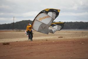
Mel returns to shore. Picture was taken in 2006 when Lake Lanier was unusually low. This would be underwater at full pond. Picture from our Foto Gallery http://windsurfatlanta.org/gallery/v/album41/
Humorous nickname for Old Federal Park alluding to its popularity with the local kitesurfing community. Please see the page for Old Federal Park for complete information. There is no actual park with this name.
Recommended Wind Directions
Local Tips
Sunrise Cove or Van Pugh probably will have better wind.
Ability
Wind Shadows
Sailing Upwind
Map
<googlemap version="0.9" lat="34.225615" lon="-83.948905" zoom="13" scale="yes"> 34.227992, -83.938949, Old Federal Park Directions (A) 34.218873, -83.953197, Lake Lanier Sailing Club (B) 34.242361, -83.938176, Sunrise Cove </googlemap>
Windsurfing Sites on Lake Lanier
- About Lake Lanier
- Windsurfing on Lake Lanier
- Kiteboarding on Lake Lanier
- Keith's Bridge Park
- Lake Lanier Map
- Lake Lanier Long Distance Sail
- Lake Lanier Sailing Club Members only unless special event
- Little Ridge Park
- Mary Alice Park
- Mountain View Park
- Old Federal Park
- Sunrise Cove
- Tidwell Park
- Two Mile Creek Park
- Van Pugh
- Van Pugh South
- Vann's Tavern
- West Bank