Chatuge Lake: Difference between revisions
From WindsportAtlanta.com: Wiki
(Created page with "thumb|300px|Lake Chatuge from dam thumb|300px| thumb|300px| __TOC__ == General Informat...") |
No edit summary |
||
| (4 intermediate revisions by the same user not shown) | |||
| Line 1: | Line 1: | ||
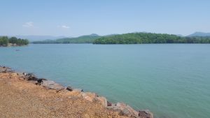
[[File:20180513_150733.jpg|thumb|300px|Lake | [[File:20180513_150733.jpg|thumb|300px|Chatuge Lake from dam]] | ||
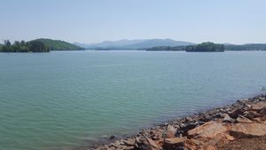
[[File:20180513_152539.jpg|thumb|300px|]] | [[File:20180513_152539.jpg|thumb|300px|]] | ||
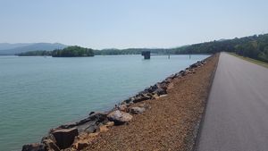
[[File:20180513_150741.jpg|thumb|300px|]] | [[File:20180513_150741.jpg|thumb|300px|]] | ||
Windsurfing on Chatuge Lake | |||
Windsurfing and Kiteboarding on {{PAGENAME}} | |||
__TOC__ | __TOC__ | ||
| Line 7: | Line 9: | ||
Information is from Langdon Garner from [https://windsportatlanta.com/content/lake-chatuge-nc-side-51518 this thread] on our forums. | Information is from Langdon Garner from [https://windsportatlanta.com/content/lake-chatuge-nc-side-51518 this thread] on our forums. | ||
Lake Chatuge straddles the GA/NC border. The south end is in Hiawassee | Lake Chatuge straddles the GA/NC border. The south end is in Hiawassee, GA and the North end goes up to Hayesville, NC. | ||
There is easy access to a launch on east side of the dam. You can often park, rig in the grass and launch within 25 ft of the water. | There is easy access to a launch on east side of the dam. You can often park, rig in the grass and launch within 25 ft of the water. | ||
S, SW and W winds are easy to launch and return. | S, SW and W winds are easy to launch and return. | ||
Latest revision as of 00:13, 16 May 2018
Windsurfing on Chatuge Lake Windsurfing and Kiteboarding on Chatuge Lake
Contents
General Information
Information is from Langdon Garner from this thread on our forums.
Lake Chatuge straddles the GA/NC border. The south end is in Hiawassee, GA and the North end goes up to Hayesville, NC. There is easy access to a launch on east side of the dam. You can often park, rig in the grass and launch within 25 ft of the water. S, SW and W winds are easy to launch and return. I usually use the longboard and there always seems to at least a breeze blowing. With the exception of holidays, boat traffic is not bad and mainly consists of pontoon boats.
Recommended Wind Directions
Legacy Directions
Local Tips
Ability
Beginner Intermediate Advanced
Wind Shadows
Northeast may be slighlty windshadowed near the shore.
Map
Loading map...
{"type":"HYBRID","minzoom":false,"maxzoom":false,"types":["ROADMAP","SATELLITE","HYBRID","TERRAIN"],"mappingservice":"googlemaps3","width":"auto","height":"800px","centre":{"text":"","title":"","link":"","lat":35.020439,"lon":-83.785229,"icon":""},"title":"","label":"","icon":"","lines":[],"polygons":[],"circles":[],"rectangles":[],"copycoords":false,"static":false,"visitedicon":"","wmsoverlay":false,"zoom":14,"layers":[],"controls":["pan","zoom","type","scale","streetview","rotate"],"zoomstyle":"DEFAULT","typestyle":"DEFAULT","autoinfowindows":false,"resizable":false,"kmlrezoom":false,"poi":true,"cluster":false,"clustergridsize":60,"clustermaxzoom":9,"clusterzoomonclick":true,"clusteraveragecenter":true,"clusterminsize":2,"imageoverlays":[],"kml":["https://windsportatlanta.com/sites/default/files/wiki/ECFW.kmz","https://windsportatlanta.com/sites/default/files/wiki/nc-windsurfing-sites.kmz","https://windsportatlanta.com/sites/default/files/wiki/Lake_Lanier_Sailing_Marks.kmz","https://windsportatlanta.com/sites/default/files/wiki/LLSC_Marks.kml"],"gkml":[],"searchmarkers":"","fullscreen":false,"scrollwheelzoom":false,"locations":[{"text":"\u003Cdiv class=\"mw-parser-output\"\u003E\u003Cp\u003E\u003Ca href=\"/wiki/Blue_Ridge_Lake\" title=\"Blue Ridge Lake\"\u003EBlue Ridge Lake\u003C/a\u003E\n\u003C/p\u003E\u003C/div\u003E","title":"Blue Ridge Lake\n","link":"","lat":34.867631,"lon":-84.249057,"icon":""},{"text":"\u003Cdiv class=\"mw-parser-output\"\u003E\u003Cp\u003E\u003Ca href=\"/wiki/Clarks_Hill_Lake\" title=\"Clarks Hill Lake\"\u003EClarks Hill Lake\u003C/a\u003E\n\u003C/p\u003E\u003C/div\u003E","title":"Clarks Hill Lake\n","link":"","lat":33.68603,"lon":-82.241638,"icon":""},{"text":"\u003Cdiv class=\"mw-parser-output\"\u003E\u003Cp\u003E\u003Ca href=\"/wiki/Hartwell_Lake\" title=\"Hartwell Lake\"\u003EHartwell Lake\u003C/a\u003E\n\u003C/p\u003E\u003C/div\u003E","title":"Hartwell Lake\n","link":"","lat":34.3745,"lon":-82.84005,"icon":""},{"text":"\u003Cdiv class=\"mw-parser-output\"\u003E\u003Cp\u003E\u003Ca href=\"/wiki/Lake_Acworth\" title=\"Lake Acworth\"\u003ELake Acworth\u003C/a\u003E\n\u003C/p\u003E\u003C/div\u003E","title":"Lake Acworth\n","link":"","lat":34.058786,"lon":-84.687724,"icon":""},{"text":"\u003Cb\u003E\u003Cdiv class=\"mw-parser-output\"\u003E\u003Cp\u003E\u003Ca href=\"/wiki/Lake_Allatoona\" class=\"mw-redirect\" title=\"Lake Allatoona\"\u003ELake Allatoona\u003C/a\u003E\n\u003C/p\u003E\u003C/div\u003E\u003C/b\u003E\u003Cdiv class=\"mw-parser-output\"\u003E\u003Cp\u003EClosest large lake to Cobb County and NW Atlanta\n\u003C/p\u003E\u003C/div\u003E","title":"Lake Allatoona\n","link":"","lat":34.160076,"lon":-84.636658,"icon":""},{"text":"\u003Cb\u003E\u003Cdiv class=\"mw-parser-output\"\u003E\u003Cp\u003EDames Ferry Park\n\u003C/p\u003E\u003C/div\u003E\u003C/b\u003E\u003Cdiv class=\"mw-parser-output\"\u003E\u003Cp\u003E\u003Ca href=\"/wiki/Lake_Juliette\" title=\"Lake Juliette\"\u003ELake Juliette\u003C/a\u003E\u003Cbr /\u003EPower plant warmed smaller lake southeast of Atlanta and close to Macon\n\u003C/p\u003E\u003C/div\u003E","title":"Dames Ferry Park\n","link":"","lat":33.040806,"lon":-83.7613577,"icon":"/w2/images/b/b3/Windsurf.png"},{"text":"\u003Cb\u003E\u003Cdiv class=\"mw-parser-output\"\u003E\u003Cp\u003E\u003Ca href=\"/wiki/Lake_Lanier\" title=\"Lake Lanier\"\u003ELake Lanier\u003C/a\u003E\n\u003C/p\u003E\u003C/div\u003E\u003C/b\u003E\u003Cdiv class=\"mw-parser-output\"\u003E\u003Cp\u003EAtlanta's most popular site with a number of sites, almost all on the south lake.\n\u003C/p\u003E\u003C/div\u003E","title":"Lake Lanier\n","link":"","lat":34.210061,"lon":-83.955505,"icon":""},{"text":"\u003Cdiv class=\"mw-parser-output\"\u003E\u003Cp\u003E\u003Ca href=\"/wiki/Lake_Oconee\" title=\"Lake Oconee\"\u003ELake Oconee\u003C/a\u003E\n\u003C/p\u003E\u003C/div\u003E","title":"Lake Oconee\n","link":"","lat":33.468432,"lon":-83.2797617,"icon":""},{"text":"\u003Cdiv class=\"mw-parser-output\"\u003E\u003Cp\u003ELake Weiss\n\u003C/p\u003E\u003C/div\u003E","title":"Lake Weiss\n","link":"","lat":34.189436,"lon":-85.638176,"icon":""},{"text":"\u003Cdiv class=\"mw-parser-output\"\u003E\u003Cp\u003E\u003Ca href=\"/wiki/Lake_Zwerner\" title=\"Lake Zwerner\"\u003ELake Zwerner\u003C/a\u003E\n\u003C/p\u003E\u003C/div\u003E","title":"Lake Zwerner\n","link":"","lat":34.549311,"lon":-83.971288,"icon":""},{"text":"\u003Cb\u003E\u003Cdiv class=\"mw-parser-output\"\u003E\u003Cp\u003E\u003Ca href=\"/wiki/Sparks_Reservoir\" title=\"Sparks Reservoir\"\u003ESparks Reservoir\u003C/a\u003E\n\u003C/p\u003E\u003C/div\u003E\u003C/b\u003E\u003Cdiv class=\"mw-parser-output\"\u003E\u003Cp\u003ESweetwater State Park\n\u003C/p\u003E\u003C/div\u003E","title":"Sparks Reservoir\n","link":"","lat":33.757978,"lon":-84.638652,"icon":""},{"text":"\u003Cdiv class=\"mw-parser-output\"\u003E\u003Cp\u003E\u003Ca href=\"/wiki/St._Simons_Island\" title=\"St. Simons Island\"\u003ESt. Simons Island\u003C/a\u003E\n\u003C/p\u003E\u003C/div\u003E","title":"St. Simons Island\n","link":"","lat":31.144332,"lon":-81.370302,"icon":""},{"text":"\u003Cb\u003E\u003Cdiv class=\"mw-parser-output\"\u003E\u003Cp\u003E\u003Ca href=\"/wiki/Tybee_Island\" title=\"Tybee Island\"\u003ETybee Island\u003C/a\u003E\n\u003C/p\u003E\u003C/div\u003E\u003C/b\u003E\u003Cdiv class=\"mw-parser-output\"\u003E\u003Cp\u003E1996 Olympic Sailing Venue\n\u003C/p\u003E\u003C/div\u003E","title":"Tybee Island\n","link":"","lat":32.019911,"lon":-80.851876,"icon":""},{"text":"\u003Cb\u003E\u003Cdiv class=\"mw-parser-output\"\u003E\u003Cp\u003E\u003Ca href=\"/wiki/West_Point_Lake\" title=\"West Point Lake\"\u003EWest Point Lake\u003C/a\u003E\n\u003C/p\u003E\u003C/div\u003E\u003C/b\u003E\u003Cdiv class=\"mw-parser-output\"\u003E\u003Cp\u003EAbout one hour from Hartsfield Airport West Point Lake\n\u003C/p\u003E\u003C/div\u003E","title":"West Point Lake\n","link":"","lat":32.933157,"lon":-85.182332,"icon":""},{"text":"\u003Cdiv class=\"mw-parser-output\"\u003E\u003Cp\u003E\u003Ca href=\"/wiki/Lake_Russell\" title=\"Lake Russell\"\u003ELake Russell\u003C/a\u003E\n\u003C/p\u003E\u003C/div\u003E","title":"Lake Russell\n","link":"","lat":34.034612,"lon":-82.605309,"icon":""},{"text":"\u003Cdiv class=\"mw-parser-output\"\u003E\u003Cp\u003E\u003Ca href=\"/wiki/Walter_F._George_Reservoir\" title=\"Walter F. George Reservoir\"\u003EWalter_F._George_Reservoir\u003C/a\u003E\n\u003C/p\u003E\u003C/div\u003E","title":"Walter_F._George_Reservoir\n","link":"","lat":31.731724,"lon":-85.108659,"icon":""},{"text":"\u003Cb\u003E\u003Cdiv class=\"mw-parser-output\"\u003E\u003Cp\u003ESouth Shore Park\n\u003C/p\u003E\u003C/div\u003E\u003C/b\u003E\u003Cdiv class=\"mw-parser-output\"\u003E\u003Cp\u003E\u003Ca href=\"/wiki/Lake_Acworth\" title=\"Lake Acworth\"\u003ELake Acworth\u003C/a\u003E\n\u003C/p\u003E\u003C/div\u003E","title":"South Shore Park\n","link":"","lat":34.055958,"lon":-84.691304,"icon":""},{"text":"\u003Cb\u003E\u003Cdiv class=\"mw-parser-output\"\u003E\u003Cp\u003ECauble Park Boat Launch\n\u003C/p\u003E\u003C/div\u003E\u003C/b\u003E\u003Cdiv class=\"mw-parser-output\"\u003E\u003Cp\u003E\u003Ca href=\"/wiki/Lake_Allatoona\" class=\"mw-redirect\" title=\"Lake Allatoona\"\u003ELake Allatoona\u003C/a\u003E\n\u003C/p\u003E\u003C/div\u003E","title":"Cauble Park Boat Launch\n","link":"","lat":34.059405,"lon":-84.681108,"icon":""},{"text":"\u003Cb\u003E\u003Cdiv class=\"mw-parser-output\"\u003E\u003Cp\u003E\u003Ca href=\"/wiki/Fields_Landing_Park\" title=\"Fields Landing Park\"\u003EFields Landing Park\u003C/a\u003E\n\u003C/p\u003E\u003C/div\u003E\u003C/b\u003E\u003Cdiv class=\"mw-parser-output\"\u003E\u003Cp\u003E\u003Ca href=\"/wiki/Lake_Allatoona\" class=\"mw-redirect\" title=\"Lake Allatoona\"\u003ELake Allatoona\u003C/a\u003E\n\u003C/p\u003E\u003C/div\u003E","title":"Fields Landing Park\n","link":"","lat":34.202567,"lon":-84.561206,"icon":""},{"text":"\u003Cb\u003E\u003Cdiv class=\"mw-parser-output\"\u003E\u003Cp\u003E\u003Ca href=\"/wiki/Galts_Ferry_Park\" title=\"Galts Ferry Park\"\u003EGalts Ferry Park\u003C/a\u003E\n\u003C/p\u003E\u003C/div\u003E\u003C/b\u003E\u003Cdiv class=\"mw-parser-output\"\u003E\u003Cp\u003E\u003Ca href=\"/wiki/Lake_Allatoona\" class=\"mw-redirect\" title=\"Lake Allatoona\"\u003ELake Allatoona\u003C/a\u003E\n\u003C/p\u003E\u003C/div\u003E","title":"Galts Ferry Park\n","link":"","lat":34.133017,"lon":-84.645809,"icon":"/w2/images/b/b3/Windsurf.png"},{"text":"\u003Cb\u003E\u003Cdiv class=\"mw-parser-output\"\u003E\u003Cp\u003E\u003Ca href=\"/wiki/Old_Hwy_41_Recreation_Area\" title=\"Old Hwy 41 Recreation Area\"\u003EOld Hwy 41 Recreation Area\u003C/a\u003E\n\u003C/p\u003E\u003C/div\u003E\u003C/b\u003E\u003Cdiv class=\"mw-parser-output\"\u003E\u003Cp\u003E\u003Ca href=\"/wiki/Lake_Allatoona\" class=\"mw-redirect\" title=\"Lake Allatoona\"\u003ELake Allatoona\u003C/a\u003E\n\u003C/p\u003E\u003C/div\u003E","title":"Old Hwy 41 Recreation Area\n","link":"","lat":34.087083,"lon":-84.704129,"icon":""},{"text":"\u003Cb\u003E\u003Cdiv class=\"mw-parser-output\"\u003E\u003Cp\u003E\u003Ca href=\"/wiki/Victoria_Landing\" title=\"Victoria Landing\"\u003EVictoria Landing\u003C/a\u003E\n\u003C/p\u003E\u003C/div\u003E\u003C/b\u003E\u003Cdiv class=\"mw-parser-output\"\u003E\u003Cp\u003E\u003Ca href=\"/wiki/Lake_Allatoona\" class=\"mw-redirect\" title=\"Lake Allatoona\"\u003ELake Allatoona\u003C/a\u003E\n\u003C/p\u003E\u003C/div\u003E","title":"Victoria Landing\n","link":"","lat":34.152521,"lon":-84.620567,"icon":""},{"text":"\u003Cb\u003E\u003Cdiv class=\"mw-parser-output\"\u003E\u003Cp\u003E\u003Ca href=\"/wiki/Sweetwater_Park\" title=\"Sweetwater Park\"\u003ESweetwater Park\u003C/a\u003E\n\u003C/p\u003E\u003C/div\u003E\u003C/b\u003E\u003Cdiv class=\"mw-parser-output\"\u003E\u003Cp\u003E\u003Ca href=\"/wiki/Lake_Allatoona\" class=\"mw-redirect\" title=\"Lake Allatoona\"\u003ELake Allatoona\u003C/a\u003E\n\u003C/p\u003E\u003C/div\u003E","title":"Sweetwater Park\n","link":"","lat":34.19286,"lon":-84.582164,"icon":""},{"text":"\u003Cb\u003E\u003Cdiv class=\"mw-parser-output\"\u003E\u003Cp\u003E\u003Ca href=\"/wiki/Websters_Ferry_Landing\" title=\"Websters Ferry Landing\"\u003EWebsters Ferry Landing\u003C/a\u003E\n\u003C/p\u003E\u003C/div\u003E\u003C/b\u003E\u003Cdiv class=\"mw-parser-output\"\u003E\u003Cp\u003E\u003Ca href=\"/wiki/Lake_Allatoona\" class=\"mw-redirect\" title=\"Lake Allatoona\"\u003ELake Allatoona\u003C/a\u003E\n\u003C/p\u003E\u003C/div\u003E","title":"Websters Ferry Landing\n","link":"","lat":34.153804,"lon":-84.69237,"icon":"/w2/images/b/b3/Windsurf.png"},{"text":"\u003Cb\u003E\u003Cdiv class=\"mw-parser-output\"\u003E\u003Cp\u003E\u003Ca href=\"/wiki/Azalea_Drive_Park\" title=\"Azalea Drive Park\"\u003EAzalea Drive Park\u003C/a\u003E\n\u003C/p\u003E\u003C/div\u003E\u003C/b\u003E\u003Cdiv class=\"mw-parser-output\"\u003E\u003Cp\u003EChattahoochee River in North Fulton Co.\n\u003C/p\u003E\u003C/div\u003E","title":"Azalea Drive Park\n","link":"","lat":34.002109,"lon":-84.363194,"icon":""},{"text":"\u003Cb\u003E\u003Cdiv class=\"mw-parser-output\"\u003E\u003Cp\u003EAqualand Marina\n\u003C/p\u003E\u003C/div\u003E\u003C/b\u003E\u003Cdiv class=\"mw-parser-output\"\u003E\u003Cp\u003E\u003Ca href=\"/wiki/Lake_Lanier\" title=\"Lake Lanier\"\u003ELake Lanier\u003C/a\u003E\n\u003C/p\u003E\u003C/div\u003E","title":"Aqualand Marina\n","link":"","lat":34.203541,"lon":-83.968389,"icon":""},{"text":"\u003Cb\u003E\u003Cdiv class=\"mw-parser-output\"\u003E\u003Cp\u003EBozo Island\n\u003C/p\u003E\u003C/div\u003E\u003C/b\u003E\u003Cdiv class=\"mw-parser-output\"\u003E\u003Cp\u003E\u003Ca href=\"/wiki/Lake_Lanier\" title=\"Lake Lanier\"\u003ELake Lanier\u003C/a\u003E\n\u003C/p\u003E\u003C/div\u003E","title":"Bozo Island\n","link":"","lat":34.188684,"lon":-83.975309,"icon":""},{"text":"\u003Cb\u003E\u003Cdiv class=\"mw-parser-output\"\u003E\u003Cp\u003EBrowns Bridge\n\u003C/p\u003E\u003C/div\u003E\u003C/b\u003E\u003Cdiv class=\"mw-parser-output\"\u003E\u003Cp\u003E\u003Ca href=\"/wiki/Lake_Lanier\" title=\"Lake Lanier\"\u003ELake Lanier\u003C/a\u003E\n\u003C/p\u003E\u003C/div\u003E","title":"Browns Bridge\n","link":"","lat":34.261517,"lon":-83.951308,"icon":""},{"text":"\u003Cb\u003E\u003Cdiv class=\"mw-parser-output\"\u003E\u003Cp\u003EHolly Park\n\u003C/p\u003E\u003C/div\u003E\u003C/b\u003E\u003Cdiv class=\"mw-parser-output\"\u003E\u003Cp\u003E\u003Ca href=\"/wiki/Lake_Lanier\" title=\"Lake Lanier\"\u003ELake Lanier\u003C/a\u003E\n\u003C/p\u003E\u003C/div\u003E","title":"Holly Park\n","link":"","lat":34.335369,"lon":-83.852341,"icon":"/w2/images/b/b3/Windsurf.png"},{"text":"\u003Cb\u003E\u003Cdiv class=\"mw-parser-output\"\u003E\u003Cp\u003E\u003Ca href=\"/wiki/Keith%27s_Bridge_Park\" title=\"Keith\u0026#39;s Bridge Park\"\u003EKeith's Bridge Park\u003C/a\u003E\n\u003C/p\u003E\u003C/div\u003E\u003C/b\u003E\u003Cdiv class=\"mw-parser-output\"\u003E\u003Cp\u003E\u003Ca href=\"/wiki/Lake_Lanier\" title=\"Lake Lanier\"\u003ELake Lanier\u003C/a\u003E\n\u003C/p\u003E\u003C/div\u003E","title":"Keith's Bridge Park\n","link":"","lat":34.279973,"lon":-83.943069,"icon":""},{"text":"\u003Cb\u003E\u003Cdiv class=\"mw-parser-output\"\u003E\u003Cp\u003ELake Lanier Islands\n\u003C/p\u003E\u003C/div\u003E\u003C/b\u003E\u003Cdiv class=\"mw-parser-output\"\u003E\u003Cp\u003E\u003Ca href=\"/wiki/Lake_Lanier\" title=\"Lake Lanier\"\u003ELake Lanier\u003C/a\u003E\n\u003C/p\u003E\u003C/div\u003E","title":"Lake Lanier Islands\n","link":"","lat":34.187071,"lon":-84.017484,"icon":""},{"text":"\u003Cb\u003E\u003Cdiv class=\"mw-parser-output\"\u003E\u003Cp\u003E\u003Ca href=\"/wiki/Lake_Lanier_Sailing_Club_(LLSC)\" title=\"Lake Lanier Sailing Club (LLSC)\"\u003ELake Lanier Sailing Club\u003C/a\u003E\n\u003C/p\u003E\u003C/div\u003E\u003C/b\u003E\u003Cdiv class=\"mw-parser-output\"\u003E\u003Cp\u003E\u003Ca href=\"/wiki/Lake_Lanier\" title=\"Lake Lanier\"\u003ELake Lanier\u003C/a\u003E\u003Cbr /\u003E Special Events Only\n\u003C/p\u003E\u003C/div\u003E","title":"Lake Lanier Sailing Club\n","link":"","lat":34.218561,"lon":-83.955225,"icon":"/w2/images/b/b3/Windsurf.png"},{"text":"\u003Cb\u003E\u003Cdiv class=\"mw-parser-output\"\u003E\u003Cp\u003E\u003Ca href=\"/wiki/Little_Ridge_Park\" title=\"Little Ridge Park\"\u003ELittle Ridge Park\u003C/a\u003E\n\u003C/p\u003E\u003C/div\u003E\u003C/b\u003E\u003Cdiv class=\"mw-parser-output\"\u003E\u003Cp\u003E\u003Ca href=\"/wiki/Lake_Lanier\" title=\"Lake Lanier\"\u003ELake Lanier\u003C/a\u003E\n\u003C/p\u003E\u003C/div\u003E","title":"Little Ridge Park\n","link":"","lat":34.192942,"lon":-84.089724,"icon":""},{"text":"\u003Cb\u003E\u003Cdiv class=\"mw-parser-output\"\u003E\u003Cp\u003E\u003Ca href=\"/wiki/Mary_Alice_Park\" title=\"Mary Alice Park\"\u003EMary Alice Park\u003C/a\u003E\n\u003C/p\u003E\u003C/div\u003E\u003C/b\u003E\u003Cdiv class=\"mw-parser-output\"\u003E\u003Cp\u003E\u003Ca href=\"/wiki/Lake_Lanier\" title=\"Lake Lanier\"\u003ELake Lanier\u003C/a\u003E\n\u003C/p\u003E\u003C/div\u003E","title":"Mary Alice Park\n","link":"","lat":34.20088,"lon":-84.098259,"icon":""},{"text":"\u003Cb\u003E\u003Cdiv class=\"mw-parser-output\"\u003E\u003Cp\u003E\u003Ca href=\"/wiki/Mountain_View_Park\" title=\"Mountain View Park\"\u003EMountain View Park\u003C/a\u003E\n\u003C/p\u003E\u003C/div\u003E\u003C/b\u003E\u003Cdiv class=\"mw-parser-output\"\u003E\u003Cp\u003E\u003Ca href=\"/wiki/Lake_Lanier\" title=\"Lake Lanier\"\u003ELake Lanier\u003C/a\u003E\n\u003C/p\u003E\u003C/div\u003E","title":"Mountain View Park\n","link":"","lat":34.252906,"lon":-83.950762,"icon":""},{"text":"\u003Cb\u003E\u003Cdiv class=\"mw-parser-output\"\u003E\u003Cp\u003E\u003Ca href=\"/wiki/Old_Federal_Park\" title=\"Old Federal Park\"\u003EOld Federal Park\u003C/a\u003E\n\u003C/p\u003E\u003C/div\u003E\u003C/b\u003E\u003Cdiv class=\"mw-parser-output\"\u003E\u003Cp\u003E\u003Ca href=\"/wiki/Lake_Lanier\" title=\"Lake Lanier\"\u003ELake Lanier\u003C/a\u003E\n\u003C/p\u003E\u003C/div\u003E","title":"Old Federal Park\n","link":"","lat":34.228834,"lon":-83.938716,"icon":"/w2/images/b/b3/Windsurf.png"},{"text":"\u003Cb\u003E\u003Cdiv class=\"mw-parser-output\"\u003E\u003Cp\u003EPort Royal Marina\n\u003C/p\u003E\u003C/div\u003E\u003C/b\u003E\u003Cdiv class=\"mw-parser-output\"\u003E\u003Cp\u003E\u003Ca href=\"/wiki/Lake_Lanier\" title=\"Lake Lanier\"\u003ELake Lanier\u003C/a\u003E\n\u003C/p\u003E\u003C/div\u003E","title":"Port Royal Marina\n","link":"","lat":34.25045,"lon":-83.957231,"icon":""},{"text":"\u003Cb\u003E\u003Cdiv class=\"mw-parser-output\"\u003E\u003Cp\u003E\u003Ca href=\"/wiki/Sunrise_Cove\" title=\"Sunrise Cove\"\u003ESunrise Cove\u003C/a\u003E\n\u003C/p\u003E\u003C/div\u003E\u003C/b\u003E\u003Cdiv class=\"mw-parser-output\"\u003E\u003Cp\u003E\u003Ca href=\"/wiki/Lake_Lanier\" title=\"Lake Lanier\"\u003ELake Lanier\u003C/a\u003E\n\u003C/p\u003E\u003C/div\u003E","title":"Sunrise Cove\n","link":"","lat":34.242263,"lon":-83.937544,"icon":"/w2/images/b/b3/Windsurf.png"},{"text":"\u003Cb\u003E\u003Cdiv class=\"mw-parser-output\"\u003E\u003Cp\u003EThree Sisters Islands\n\u003C/p\u003E\u003C/div\u003E\u003C/b\u003E\u003Cdiv class=\"mw-parser-output\"\u003E\u003Cp\u003E\u003Ca href=\"/wiki/Lake_Lanier\" title=\"Lake Lanier\"\u003ELake Lanier\u003C/a\u003E\n\u003C/p\u003E\u003C/div\u003E","title":"Three Sisters Islands\n","link":"","lat":34.197977,"lon":-84.007753,"icon":""},{"text":"\u003Cb\u003E\u003Cdiv class=\"mw-parser-output\"\u003E\u003Cp\u003E\u003Ca href=\"/wiki/Tidwell_Park\" title=\"Tidwell Park\"\u003ETidwell Park\u003C/a\u003E\n\u003C/p\u003E\u003C/div\u003E\u003C/b\u003E\u003Cdiv class=\"mw-parser-output\"\u003E\u003Cp\u003E\u003Ca href=\"/wiki/Lake_Lanier\" title=\"Lake Lanier\"\u003ELake Lanier\u003C/a\u003E\n\u003C/p\u003E\u003C/div\u003E","title":"Tidwell Park\n","link":"","lat":34.194503,"lon":-84.064363,"icon":"/w2/images/b/b3/Windsurf.png"},{"text":"\u003Cb\u003E\u003Cdiv class=\"mw-parser-output\"\u003E\u003Cp\u003E\u003Ca href=\"/wiki/Two_Mile_Creek_Park\" title=\"Two Mile Creek Park\"\u003ETwo Mile Creek Park\u003C/a\u003E\n\u003C/p\u003E\u003C/div\u003E\u003C/b\u003E\u003Cdiv class=\"mw-parser-output\"\u003E\u003Cp\u003E\u003Ca href=\"/wiki/Lake_Lanier\" title=\"Lake Lanier\"\u003ELake Lanier\u003C/a\u003E\n\u003C/p\u003E\u003C/div\u003E","title":"Two Mile Creek Park\n","link":"","lat":34.221441,"lon":-83.999303,"icon":""},{"text":"\u003Cb\u003E\u003Cdiv class=\"mw-parser-output\"\u003E\u003Cp\u003E\u003Ca href=\"/wiki/Van_Pugh_Park\" title=\"Van Pugh Park\"\u003EVan Pugh Park\u003C/a\u003E\n\u003C/p\u003E\u003C/div\u003E\u003C/b\u003E\u003Cdiv class=\"mw-parser-output\"\u003E\u003Cp\u003E\u003Ca href=\"/wiki/Lake_Lanier\" title=\"Lake Lanier\"\u003ELake Lanier\u003C/a\u003E\n\u003C/p\u003E\u003C/div\u003E","title":"Van Pugh Park\n","link":"","lat":34.188275,"lon":-83.980673,"icon":"/w2/images/b/b3/Windsurf.png"},{"text":"\u003Cb\u003E\u003Cdiv class=\"mw-parser-output\"\u003E\u003Cp\u003E\u003Ca href=\"/wiki/Van_Pugh_South_Park\" title=\"Van Pugh South Park\"\u003EVan Pugh South Park\u003C/a\u003E\n\u003C/p\u003E\u003C/div\u003E\u003C/b\u003E\u003Cdiv class=\"mw-parser-output\"\u003E\u003Cp\u003E\u003Ca href=\"/wiki/Lake_Lanier\" title=\"Lake Lanier\"\u003ELake Lanier\u003C/a\u003E\n\u003C/p\u003E\u003C/div\u003E","title":"Van Pugh South Park\n","link":"","lat":34.185055,"lon":-83.990416,"icon":""},{"text":"\u003Cb\u003E\u003Cdiv class=\"mw-parser-output\"\u003E\u003Cp\u003E\u003Ca href=\"/wiki/Vann%27s_Tavern_Park\" title=\"Vann\u0026#39;s Tavern Park\"\u003EVann's Tavern Park\u003C/a\u003E\n\u003C/p\u003E\u003C/div\u003E\u003C/b\u003E\u003Cdiv class=\"mw-parser-output\"\u003E\u003Cp\u003E\u003Ca href=\"/wiki/Lake_Lanier\" title=\"Lake Lanier\"\u003ELake Lanier\u003C/a\u003E\n\u003C/p\u003E\u003C/div\u003E","title":"Vann's Tavern Park\n","link":"","lat":34.234884,"lon":-83.978571,"icon":"/w2/images/b/b3/Windsurf.png"},{"text":"\u003Cb\u003E\u003Cdiv class=\"mw-parser-output\"\u003E\u003Cp\u003E\u003Ca href=\"/wiki/West_Bank_Park\" title=\"West Bank Park\"\u003EWest Bank Park\u003C/a\u003E\n\u003C/p\u003E\u003C/div\u003E\u003C/b\u003E\u003Cdiv class=\"mw-parser-output\"\u003E\u003Cp\u003E\u003Ca href=\"/wiki/Lake_Lanier\" title=\"Lake Lanier\"\u003ELake Lanier\u003C/a\u003E\u003Cbr /\u003E No trailers\n\u003C/p\u003E\u003C/div\u003E","title":"West Bank Park\n","link":"","lat":34.167729,"lon":-84.07041,"icon":""},{"text":"\u003Cb\u003E\u003Cdiv class=\"mw-parser-output\"\u003E\u003Cp\u003EBroyles Rec. Area\n\u003C/p\u003E\u003C/div\u003E\u003C/b\u003E\u003Cdiv class=\"mw-parser-output\"\u003E\u003Cp\u003E\u003Ca href=\"/wiki/Hartwell_Lake\" title=\"Hartwell Lake\"\u003EHartwell Lake\u003C/a\u003E\n\u003C/p\u003E\u003C/div\u003E","title":"Broyles Rec. Area\n","link":"","lat":34.51574,"lon":-82.83089,"icon":"/w2/images/b/b3/Windsurf.png"},{"text":"\u003Cb\u003E\u003Cdiv class=\"mw-parser-output\"\u003E\u003Cp\u003EElrod Ferry Rec. Area\n\u003C/p\u003E\u003C/div\u003E\u003C/b\u003E\u003Cdiv class=\"mw-parser-output\"\u003E\u003Cp\u003E\u003Ca href=\"/wiki/Hartwell_Lake\" title=\"Hartwell Lake\"\u003EHartwell Lake\u003C/a\u003E\n\u003C/p\u003E\u003C/div\u003E","title":"Elrod Ferry Rec. Area\n","link":"","lat":34.36325,"lon":-82.85198,"icon":"/w2/images/b/b3/Windsurf.png"},{"text":"\u003Cb\u003E\u003Cdiv class=\"mw-parser-output\"\u003E\u003Cp\u003EGreen Pond Landing\n\u003C/p\u003E\u003C/div\u003E\u003C/b\u003E\u003Cdiv class=\"mw-parser-output\"\u003E\u003Cp\u003E\u003Ca href=\"/wiki/Hartwell_Lake\" title=\"Hartwell Lake\"\u003EHartwell Lake\u003C/a\u003E\n\u003C/p\u003E\u003C/div\u003E","title":"Green Pond Landing\n","link":"","lat":34.5145,"lon":-82.79,"icon":"/w2/images/b/b3/Windsurf.png"},{"text":"\u003Cb\u003E\u003Cdiv class=\"mw-parser-output\"\u003E\u003Cp\u003ELong Point Rec. Area\n\u003C/p\u003E\u003C/div\u003E\u003C/b\u003E\u003Cdiv class=\"mw-parser-output\"\u003E\u003Cp\u003E\u003Ca href=\"/wiki/Hartwell_Lake\" title=\"Hartwell Lake\"\u003EHartwell Lakee\u003C/a\u003E\n\u003C/p\u003E\u003C/div\u003E","title":"Long Point Rec. Area\n","link":"","lat":34.38427,"lon":-82.853846,"icon":"/w2/images/b/b3/Windsurf.png"},{"text":"\u003Cb\u003E\u003Cdiv class=\"mw-parser-output\"\u003E\u003Cp\u003ESinging Pines Rec. Area\n\u003C/p\u003E\u003C/div\u003E\u003C/b\u003E\u003Cdiv class=\"mw-parser-output\"\u003E\u003Cp\u003E\u003Ca href=\"/wiki/Hartwell_Lake\" title=\"Hartwell Lake\"\u003EHartwell Lake\u003C/a\u003E\n\u003C/p\u003E\u003C/div\u003E","title":"Singing Pines Rec. Area\n","link":"","lat":34.37618,"lon":-82.8181,"icon":"/w2/images/b/b3/Windsurf.png"},{"text":"\u003Cb\u003E\u003Cdiv class=\"mw-parser-output\"\u003E\u003Cp\u003ESadler's Creek State Park\n\u003C/p\u003E\u003C/div\u003E\u003C/b\u003E\u003Cdiv class=\"mw-parser-output\"\u003E\u003Cp\u003E\u003Ca href=\"/wiki/Hartwell_Lake\" title=\"Hartwell Lake\"\u003EHartwell Lake\u003C/a\u003E\n\u003C/p\u003E\u003C/div\u003E","title":"Sadler's Creek State Park\n","link":"","lat":34.43013,"lon":-82.831,"icon":"/w2/images/b/b3/Windsurf.png"},{"text":"\u003Cb\u003E\u003Cdiv class=\"mw-parser-output\"\u003E\u003Cp\u003ER. Shaefer Heard Park\n\u003C/p\u003E\u003C/div\u003E\u003C/b\u003E\u003Cdiv class=\"mw-parser-output\"\u003E\u003Cp\u003E\u003Ca href=\"/wiki/West_Point_Lake#R._Shaefer_Heard_Park\" title=\"West Point Lake\"\u003EWest Point Lake#R. Shaefer Heard Park\u003C/a\u003E Launch for SW, W, NW \u003Ca rel=\"nofollow\" class=\"external text\" href=\"http://g.co/maps/axquz\"\u003EDirections\u003C/a\u003E\n\u003C/p\u003E\u003C/div\u003E","title":"R. Shaefer Heard Park\n","link":"","lat":32.921216,"lon":-85.167317,"icon":"/w2/images/b/b3/Windsurf.png"},{"text":"\u003Cb\u003E\u003Cdiv class=\"mw-parser-output\"\u003E\u003Cp\u003EWest Launch\n\u003C/p\u003E\u003C/div\u003E\u003C/b\u003E\u003Cdiv class=\"mw-parser-output\"\u003E\u003Cp\u003E\u003Ca href=\"/wiki/West_Point_Lake#West_Launch\" title=\"West Point Lake\"\u003EWest Point Lake#West Launch\u003C/a\u003E Launch for N, NE, E, SE \u003Ca rel=\"nofollow\" class=\"external text\" href=\"http://g.co/maps/bmbd9\"\u003EDirections\u003C/a\u003E\n\u003C/p\u003E\u003C/div\u003E","title":"West Launch\n","link":"","lat":32.926277,"lon":-85.195989,"icon":"/w2/images/b/b3/Windsurf.png"},{"text":"\u003Cb\u003E\u003Cdiv class=\"mw-parser-output\"\u003E\u003Cp\u003EWest Overlook Park\n\u003C/p\u003E\u003C/div\u003E\u003C/b\u003E\u003Cdiv class=\"mw-parser-output\"\u003E\u003Cp\u003E\u003Ca href=\"/wiki/West_Point_Lake\" title=\"West Point Lake\"\u003EWest Point Lake\u003C/a\u003E Alternate launch for N, NE, S, SE\n\u003C/p\u003E\u003C/div\u003E","title":"West Overlook Park\n","link":"","lat":32.932788,"lon":-85.197823,"icon":"/w2/images/b/b3/Windsurf.png"},{"text":"\u003Cb\u003E\u003Cdiv class=\"mw-parser-output\"\u003E\u003Cp\u003EWest Point (town)\n\u003C/p\u003E\u003C/div\u003E\u003C/b\u003E\u003Cdiv class=\"mw-parser-output\"\u003E\u003Cp\u003E\u003Ca rel=\"nofollow\" class=\"external text\" href=\"http://g.co/maps/y2m32\"\u003EDirections\u003C/a\u003E to city of West Point. From here you can go to either west or east side.\n\u003C/p\u003E\u003C/div\u003E","title":"West Point (town)\n","link":"","lat":32.876793,"lon":-85.174192,"icon":""},{"text":"\u003Cb\u003E\u003Cdiv class=\"mw-parser-output\"\u003E\u003Cp\u003EScott's Landing\n\u003C/p\u003E\u003C/div\u003E\u003C/b\u003E\u003Cdiv class=\"mw-parser-output\"\u003E\u003Cp\u003E\u003Ca href=\"/wiki/Clarks_Hill_Lake\" title=\"Clarks Hill Lake\"\u003EClarks Hill Lake\u003C/a\u003E\n\u003C/p\u003E\u003C/div\u003E","title":"Scott's Landing\n","link":"","lat":33.681376,"lon":-82.204093,"icon":"/w2/images/b/b3/Windsurf.png"},{"text":"\u003Cb\u003E\u003Cdiv class=\"mw-parser-output\"\u003E\u003Cp\u003EModoc Boat Ramp\n\u003C/p\u003E\u003C/div\u003E\u003C/b\u003E\u003Cdiv class=\"mw-parser-output\"\u003E\u003Cp\u003E\u003Ca href=\"/wiki/Clarks_Hill_Lake\" title=\"Clarks Hill Lake\"\u003EClarks Hill Lake\u003C/a\u003E\n\u003C/p\u003E\u003C/div\u003E","title":"Modoc Boat Ramp\n","link":"","lat":33.7302916,"lon":-82.245113,"icon":""},{"text":"\u003Cb\u003E\u003Cdiv class=\"mw-parser-output\"\u003E\u003Cp\u003ELake Springs (Center Point)\n\u003C/p\u003E\u003C/div\u003E\u003C/b\u003E\u003Cdiv class=\"mw-parser-output\"\u003E\u003Cp\u003E\u003Ca href=\"/wiki/Clarks_Hill_Lake\" title=\"Clarks Hill Lake\"\u003EClarks Hill Lake\u003C/a\u003E\n\u003C/p\u003E\u003C/div\u003E","title":"Lake Springs (Center Point)\n","link":"","lat":33.672874,"lon":-82.226887,"icon":"/w2/images/b/b3/Windsurf.png"},{"text":"\u003Cb\u003E\u003Cdiv class=\"mw-parser-output\"\u003E\u003Cp\u003EModoc Shores\n\u003C/p\u003E\u003C/div\u003E\u003C/b\u003E\u003Cdiv class=\"mw-parser-output\"\u003E\u003Cp\u003E\u003Ca href=\"/wiki/Clarks_Hill_Lake\" title=\"Clarks Hill Lake\"\u003EClarks Hill Lake\u003C/a\u003E\n\u003C/p\u003E\u003C/div\u003E","title":"Modoc Shores\n","link":"","lat":33.699375,"lon":-82.2268989,"icon":""},{"text":"\u003Cb\u003E\u003Cdiv class=\"mw-parser-output\"\u003E\u003Cp\u003EWest Dam Beach\n\u003C/p\u003E\u003C/div\u003E\u003C/b\u003E\u003Cdiv class=\"mw-parser-output\"\u003E\u003Cp\u003E\u003Ca href=\"/wiki/Clarks_Hill_Lake\" title=\"Clarks Hill Lake\"\u003EClarks Hill Lake\u003C/a\u003E\n\u003C/p\u003E\u003C/div\u003E","title":"West Dam Beach\n","link":"","lat":33.659197,"lon":-82.209435,"icon":"/w2/images/b/b3/Windsurf.png"},{"text":"\u003Cb\u003E\u003Cdiv class=\"mw-parser-output\"\u003E\u003Cp\u003EOld Town Recreation Area\n\u003C/p\u003E\u003C/div\u003E\u003C/b\u003E\u003Cdiv class=\"mw-parser-output\"\u003E\u003Cp\u003E\u003Ca href=\"/wiki/Walter_F._George_Reservoir\" title=\"Walter F. George Reservoir\"\u003EWalter_F._George_Reservoir\u003C/a\u003E\n\u003C/p\u003E\u003C/div\u003E","title":"Old Town Recreation Area\n","link":"","lat":31.914354,"lon":-85.119813,"icon":""},{"text":"\u003Cb\u003E\u003Cdiv class=\"mw-parser-output\"\u003E\u003Cp\u003ESandy Creek Public Use Area\n\u003C/p\u003E\u003C/div\u003E\u003C/b\u003E\u003Cdiv class=\"mw-parser-output\"\u003E\u003Cp\u003E\u003Ca href=\"/wiki/Walter_F._George_Reservoir\" title=\"Walter F. George Reservoir\"\u003EWalter_F._George_Reservoir\u003C/a\u003E\n\u003C/p\u003E\u003C/div\u003E","title":"Sandy Creek Public Use Area\n","link":"","lat":31.664991,"lon":-85.060436,"icon":""},{"text":"\u003Cb\u003E\u003Cdiv class=\"mw-parser-output\"\u003E\u003Cp\u003EPataula Creek Public Use Area\n\u003C/p\u003E\u003C/div\u003E\u003C/b\u003E\u003Cdiv class=\"mw-parser-output\"\u003E\u003Cp\u003E\u003Ca href=\"/wiki/Walter_F._George_Reservoir\" title=\"Walter F. George Reservoir\"\u003EWalter_F._George_Reservoir\u003C/a\u003E\n\u003C/p\u003E\u003C/div\u003E","title":"Pataula Creek Public Use Area\n","link":"","lat":31.733969,"lon":-85.080231,"icon":""},{"text":"\u003Cb\u003E\u003Cdiv class=\"mw-parser-output\"\u003E\u003Cp\u003EShuck Pen Eddy Boat Ramp\n\u003C/p\u003E\u003C/div\u003E\u003C/b\u003E\u003Cdiv class=\"mw-parser-output\"\u003E\u003Cp\u003E\u003Ca href=\"/wiki/Lake_Russell\" title=\"Lake Russell\"\u003ELake Russell\u003C/a\u003E\n\u003C/p\u003E\u003C/div\u003E","title":"Shuck Pen Eddy Boat Ramp\n","link":"","lat":34.032763,"lon":-82.623092,"icon":""},{"text":"\u003Cb\u003E\u003Cdiv class=\"mw-parser-output\"\u003E\u003Cp\u003EManor Creek Boat Ramp\n\u003C/p\u003E\u003C/div\u003E\u003C/b\u003E\u003Cdiv class=\"mw-parser-output\"\u003E\u003Cp\u003E\u003Ca href=\"/wiki/Lake_Russell\" title=\"Lake Russell\"\u003ELake Russell\u003C/a\u003E\n\u003C/p\u003E\u003C/div\u003E","title":"Manor Creek Boat Ramp\n","link":"","lat":34.045423,"lon":-82.592987,"icon":""},{"text":"\u003Cb\u003E\u003Cdiv class=\"mw-parser-output\"\u003E\u003Cp\u003EElbert Boat Launch\n\u003C/p\u003E\u003C/div\u003E\u003C/b\u003E\u003Cdiv class=\"mw-parser-output\"\u003E\u003Cp\u003E\u003Ca href=\"/wiki/Lake_Russell\" title=\"Lake Russell\"\u003ELake Russell\u003C/a\u003E\n\u003C/p\u003E\u003C/div\u003E","title":"Elbert Boat Launch\n","link":"","lat":34.067041,"lon":-82.648734,"icon":""},{"text":"\u003Cb\u003E\u003Cdiv class=\"mw-parser-output\"\u003E\u003Cp\u003EParks Ferry\n\u003C/p\u003E\u003C/div\u003E\u003C/b\u003E\u003Cdiv class=\"mw-parser-output\"\u003E\u003Cp\u003E\u003Ca href=\"/wiki/Lake_Oconee\" title=\"Lake Oconee\"\u003ELake Oconee\u003C/a\u003E\n\u003C/p\u003E\u003C/div\u003E","title":"Parks Ferry\n","link":"","lat":33.523888,"lon":-83.273605,"icon":""},{"text":"\u003Cb\u003E\u003Cdiv class=\"mw-parser-output\"\u003E\u003Cp\u003EOld Salem Park\n\u003C/p\u003E\u003C/div\u003E\u003C/b\u003E\u003Cdiv class=\"mw-parser-output\"\u003E\u003Cp\u003E\u003Ca href=\"/wiki/Lake_Oconee\" title=\"Lake Oconee\"\u003ELake Oconee\u003C/a\u003E\n\u003C/p\u003E\u003C/div\u003E","title":"Old Salem Park\n","link":"","lat":33.429522,"lon":-83.246065,"icon":""},{"text":"\u003Cb\u003E\u003Cdiv class=\"mw-parser-output\"\u003E\u003Cp\u003ERedlands Boat Ramp\n\u003C/p\u003E\u003C/div\u003E\u003C/b\u003E\u003Cdiv class=\"mw-parser-output\"\u003E\u003Cp\u003E\u003Ca href=\"/wiki/Lake_Oconee\" title=\"Lake Oconee\"\u003ELake Oconee\u003C/a\u003E\u003Cbr /\u003E Possible launch spot\n\u003C/p\u003E\u003C/div\u003E","title":"Redlands Boat Ramp\n","link":"","lat":33.567865,"lon":-83.2746577,"icon":""},{"text":"\u003Cb\u003E\u003Cdiv class=\"mw-parser-output\"\u003E\u003Cp\u003EMadison Hwy Causeway\n\u003C/p\u003E\u003C/div\u003E\u003C/b\u003E\u003Cdiv class=\"mw-parser-output\"\u003E\u003Cp\u003E\u003Ca href=\"/wiki/Lake_Oconee\" title=\"Lake Oconee\"\u003ELake Oconee\u003C/a\u003E\u003Cbr /\u003E Possible launch spot\n\u003C/p\u003E\u003C/div\u003E","title":"Madison Hwy Causeway\n","link":"","lat":33.581838,"lon":-83.2779517,"icon":""},{"text":"\u003Cb\u003E\u003Cdiv class=\"mw-parser-output\"\u003E\u003Cp\u003ELake Oconee Parkway\n\u003C/p\u003E\u003C/div\u003E\u003C/b\u003E\u003Cdiv class=\"mw-parser-output\"\u003E\u003Cp\u003E\u003Ca href=\"/wiki/Lake_Oconee\" title=\"Lake Oconee\"\u003ELake Oconee\u003C/a\u003E\u003Cbr /\u003E Possible launch spot\n\u003C/p\u003E\u003C/div\u003E","title":"Lake Oconee Parkway\n","link":"","lat":33.448083,"lon":-83.2594947,"icon":""},{"text":"\u003Cb\u003E\u003Cdiv class=\"mw-parser-output\"\u003E\u003Cp\u003ELake Horton\n\u003C/p\u003E\u003C/div\u003E\u003C/b\u003E\u003Cdiv class=\"mw-parser-output\"\u003E\u003Cp\u003E\u003Ca href=\"/wiki/Infrequently_Used_Georgia_Lakes\" title=\"Infrequently Used Georgia Lakes\"\u003EInfrequently Used Georgia Lakes\u003C/a\u003E\n\u003C/p\u003E\u003C/div\u003E","title":"Lake Horton\n","link":"","lat":33.326273,"lon":-84.419506,"icon":""},{"text":"\u003Cb\u003E\u003Cdiv class=\"mw-parser-output\"\u003E\u003Cp\u003ELake Peachtree\n\u003C/p\u003E\u003C/div\u003E\u003C/b\u003E\u003Cdiv class=\"mw-parser-output\"\u003E\u003Cp\u003E\u003Ca href=\"/wiki/Infrequently_Used_Georgia_Lakes\" title=\"Infrequently Used Georgia Lakes\"\u003EInfrequently Used Georgia Lakes\u003C/a\u003E\n\u003C/p\u003E\u003C/div\u003E","title":"Lake Peachtree\n","link":"","lat":33.394234,"lon":-84.574688,"icon":""},{"text":"\u003Cb\u003E\u003Cdiv class=\"mw-parser-output\"\u003E\u003Cp\u003ELake Windward\n\u003C/p\u003E\u003C/div\u003E\u003C/b\u003E\u003Cdiv class=\"mw-parser-output\"\u003E\u003Cp\u003E\u003Ca href=\"/wiki/Infrequently_Used_Georgia_Lakes\" title=\"Infrequently Used Georgia Lakes\"\u003EInfrequently Used Georgia Lakes\u003C/a\u003E\n\u003C/p\u003E\u003C/div\u003E","title":"Lake Windward\n","link":"","lat":34.079157,"lon":-84.229305,"icon":""},{"text":"\u003Cb\u003E\u003Cdiv class=\"mw-parser-output\"\u003E\u003Cp\u003ECarters Lake\n\u003C/p\u003E\u003C/div\u003E\u003C/b\u003E\u003Cdiv class=\"mw-parser-output\"\u003E\u003Cp\u003E\u003Ca href=\"/wiki/Infrequently_Used_Georgia_Lakes\" title=\"Infrequently Used Georgia Lakes\"\u003EInfrequently Used Georgia Lakes\u003C/a\u003E\n\u003C/p\u003E\u003C/div\u003E","title":"Carters Lake\n","link":"","lat":34.60924,"lon":-84.655025,"icon":""},{"text":"\u003Cdiv class=\"mw-parser-output\"\u003E\u003Cp\u003E\u003Ca href=\"/wiki/Badin_Lake\" title=\"Badin Lake\"\u003EBadin Lake\u003C/a\u003E\n\u003C/p\u003E\u003C/div\u003E","title":"Badin Lake\n","link":"","lat":35.449322,"lon":-80.107112,"icon":""},{"text":"\u003Cb\u003E\u003Cdiv class=\"mw-parser-output\"\u003E\u003Cp\u003EBadin Public Access Area\n\u003C/p\u003E\u003C/div\u003E\u003C/b\u003E\u003Cdiv class=\"mw-parser-output\"\u003E\u003Cp\u003E\u003Ca href=\"/wiki/Badin_Lake\" title=\"Badin Lake\"\u003EBadin Lake\u003C/a\u003E\n\u003C/p\u003E\u003C/div\u003E","title":"Badin Public Access Area\n","link":"","lat":35.415973,"lon":-80.114448,"icon":"/w2/images/b/b3/Windsurf.png"},{"text":"\u003Cb\u003E\u003Cdiv class=\"mw-parser-output\"\u003E\u003Cp\u003EKings Mtn Pt W Launch\n\u003C/p\u003E\u003C/div\u003E\u003C/b\u003E\u003Cdiv class=\"mw-parser-output\"\u003E\u003Cp\u003E\u003Ca href=\"/wiki/Badin_Lake\" title=\"Badin Lake\"\u003EBadin Lake\u003C/a\u003E\n\u003C/p\u003E\u003C/div\u003E","title":"Kings Mtn Pt W Launch\n","link":"","lat":35.454302,"lon":-80.080619,"icon":"/w2/images/b/b3/Windsurf.png"},{"text":"\u003Cb\u003E\u003Cdiv class=\"mw-parser-output\"\u003E\u003Cp\u003EKings Mtn Pt SW Launch\n\u003C/p\u003E\u003C/div\u003E\u003C/b\u003E\u003Cdiv class=\"mw-parser-output\"\u003E\u003Cp\u003E\u003Ca href=\"/wiki/Badin_Lake\" title=\"Badin Lake\"\u003EBadin Lake\u003C/a\u003E\n\u003C/p\u003E\u003C/div\u003E","title":"Kings Mtn Pt SW Launch\n","link":"","lat":35.45348,"lon":-80.07997,"icon":"/w2/images/b/b3/Windsurf.png"},{"text":"\u003Cb\u003E\u003Cdiv class=\"mw-parser-output\"\u003E\u003Cp\u003EOld Whitney Rd.\n\u003C/p\u003E\u003C/div\u003E\u003C/b\u003E\u003Cdiv class=\"mw-parser-output\"\u003E\u003Cp\u003E\u003Ca href=\"/wiki/Badin_Lake\" title=\"Badin Lake\"\u003EBadin Lake\u003C/a\u003E\n\u003C/p\u003E\u003C/div\u003E","title":"Old Whitney Rd.\n","link":"","lat":35.468948,"lon":-80.137237,"icon":""},{"text":"\u003Cb\u003E\u003Cdiv class=\"mw-parser-output\"\u003E\u003Cp\u003E\u003Ca class=\"mw-selflink selflink\"\u003EChatuge Lake\u003C/a\u003E\n\u003C/p\u003E\u003C/div\u003E\u003C/b\u003E\u003Cdiv class=\"mw-parser-output\"\u003E\u003Cp\u003ENC Side\n\u003C/p\u003E\u003C/div\u003E","title":"Chatuge Lake\n","link":"","lat":35.020439,"lon":-83.785229,"icon":""},{"text":"\u003Cdiv class=\"mw-parser-output\"\u003E\u003Cp\u003E\u003Ca href=\"/wiki/Lake_Norman\" title=\"Lake Norman\"\u003ELake Norman\u003C/a\u003E\n\u003C/p\u003E\u003C/div\u003E","title":"Lake Norman\n","link":"","lat":35.464287,"lon":-80.927032,"icon":""},{"text":"\u003Cb\u003E\u003Cdiv class=\"mw-parser-output\"\u003E\u003Cp\u003EBeatty's Ford Park\n\u003C/p\u003E\u003C/div\u003E\u003C/b\u003E\u003Cdiv class=\"mw-parser-output\"\u003E\u003Cp\u003E\u003Ca href=\"/wiki/Lake_Norman\" title=\"Lake Norman\"\u003ELake Norman\u003C/a\u003E\n\u003C/p\u003E\u003C/div\u003E","title":"Beatty's Ford Park\n","link":"","lat":35.482767,"lon":-80.956129,"icon":"/w2/images/b/b3/Windsurf.png"},{"text":"\u003Cb\u003E\u003Cdiv class=\"mw-parser-output\"\u003E\u003Cp\u003EBlythe Landing Park\n\u003C/p\u003E\u003C/div\u003E\u003C/b\u003E\u003Cdiv class=\"mw-parser-output\"\u003E\u003Cp\u003E\u003Ca href=\"/wiki/Lake_Norman\" title=\"Lake Norman\"\u003ELake Norman\u003C/a\u003E\n\u003C/p\u003E\u003C/div\u003E","title":"Blythe Landing Park\n","link":"","lat":35.435902,"lon":-80.907835,"icon":"/w2/images/b/b3/Windsurf.png"},{"text":"\u003Cb\u003E\u003Cdiv class=\"mw-parser-output\"\u003E\u003Cp\u003EHager Creek Access Area\n\u003C/p\u003E\u003C/div\u003E\u003C/b\u003E\u003Cdiv class=\"mw-parser-output\"\u003E\u003Cp\u003E\u003Ca href=\"/wiki/Lake_Norman\" title=\"Lake Norman\"\u003ELake Norman\u003C/a\u003E\n\u003C/p\u003E\u003C/div\u003E","title":"Hager Creek Access Area\n","link":"","lat":35.561263,"lon":-80.952363,"icon":"/w2/images/b/b3/Windsurf.png"},{"text":"\u003Cb\u003E\u003Cdiv class=\"mw-parser-output\"\u003E\u003Cp\u003ERamsey Creek Park\n\u003C/p\u003E\u003C/div\u003E\u003C/b\u003E\u003Cdiv class=\"mw-parser-output\"\u003E\u003Cp\u003E\u003Ca href=\"/wiki/Lake_Norman\" title=\"Lake Norman\"\u003ELake Norman\u003C/a\u003E\n\u003C/p\u003E\u003C/div\u003E","title":"Ramsey Creek Park\n","link":"","lat":35.464366,"lon":-80.901894,"icon":"/w2/images/b/b3/Windsurf.png"},{"text":"\u003Cdiv class=\"mw-parser-output\"\u003E\u003Cp\u003E\u003Ca href=\"/wiki/Lake_James\" title=\"Lake James\"\u003ELake James\u003C/a\u003E\n\u003C/p\u003E\u003C/div\u003E","title":"Lake James\n","link":"","lat":35.743901,"lon":-81.883461,"icon":""},{"text":"\u003Cb\u003E\u003Cdiv class=\"mw-parser-output\"\u003E\u003Cp\u003ELake James St. Park Paddy's Creek Area\n\u003C/p\u003E\u003C/div\u003E\u003C/b\u003E\u003Cdiv class=\"mw-parser-output\"\u003E\u003Cp\u003E\u003Ca href=\"/wiki/Lake_James\" title=\"Lake James\"\u003ELake James\u003C/a\u003E\n\u003C/p\u003E\u003C/div\u003E","title":"Lake James St. Park Paddy's Creek Area\n","link":"","lat":35.750588,"lon":-81.876702,"icon":""},{"text":"\u003Cb\u003E\u003Cdiv class=\"mw-parser-output\"\u003E\u003Cp\u003EHwy 126 Boat Landing\n\u003C/p\u003E\u003C/div\u003E\u003C/b\u003E\u003Cdiv class=\"mw-parser-output\"\u003E\u003Cp\u003E\u003Ca href=\"/wiki/Lake_James\" title=\"Lake James\"\u003ELake James\u003C/a\u003E\n\u003C/p\u003E\u003C/div\u003E","title":"Hwy 126 Boat Landing\n","link":"","lat":35.74,"lon":-81.885045,"icon":""},{"text":"\u003Cdiv class=\"mw-parser-output\"\u003E\u003Cp\u003EJordan Lake\n\u003C/p\u003E\u003C/div\u003E","title":"Jordan Lake\n","link":"","lat":35.758344,"lon":-79.025528,"icon":""},{"text":"\u003Cdiv class=\"mw-parser-output\"\u003E\u003Cp\u003EEmerald Isle\n\u003C/p\u003E\u003C/div\u003E","title":"Emerald Isle\n","link":"","lat":34.67909,"lon":-76.940872,"icon":""},{"text":"\u003Cdiv class=\"mw-parser-output\"\u003E\u003Cp\u003EWrightsville Beach\n\u003C/p\u003E\u003C/div\u003E","title":"Wrightsville Beach\n","link":"","lat":34.192058,"lon":-77.800552,"icon":""},{"text":"\u003Cdiv class=\"mw-parser-output\"\u003E\u003Cp\u003EOak Island\n\u003C/p\u003E\u003C/div\u003E","title":"Oak Island\n","link":"","lat":33.913336,"lon":-78.228156,"icon":""},{"text":"\u003Cdiv class=\"mw-parser-output\"\u003E\u003Cp\u003EAvon\n\u003C/p\u003E\u003C/div\u003E","title":"Avon\n","link":"","lat":35.349689,"lon":-75.513637,"icon":""},{"text":"\u003Cdiv class=\"mw-parser-output\"\u003E\u003Cp\u003ECanadian Hole\n\u003C/p\u003E\u003C/div\u003E","title":"Canadian Hole\n","link":"","lat":35.298679,"lon":-75.514061,"icon":""},{"text":"\u003Cdiv class=\"mw-parser-output\"\u003E\u003Cp\u003ECape Hatteras\n\u003C/p\u003E\u003C/div\u003E","title":"Cape Hatteras\n","link":"","lat":35.254634,"lon":-75.52016,"icon":""},{"text":"\u003Cdiv class=\"mw-parser-output\"\u003E\u003Cp\u003EFrisco Woods\n\u003C/p\u003E\u003C/div\u003E","title":"Frisco Woods\n","link":"","lat":35.241189,"lon":-75.623258,"icon":""},{"text":"\u003Cdiv class=\"mw-parser-output\"\u003E\u003Cp\u003ENags Head\n\u003C/p\u003E\u003C/div\u003E","title":"Nags Head\n","link":"","lat":35.945943,"lon":-75.630444,"icon":""},{"text":"\u003Cdiv class=\"mw-parser-output\"\u003E\u003Cp\u003EOcracoke\n\u003C/p\u003E\u003C/div\u003E","title":"Ocracoke\n","link":"","lat":35.125787,"lon":-75.950226,"icon":""},{"text":"\u003Cdiv class=\"mw-parser-output\"\u003E\u003Cp\u003ERodanthe\n\u003C/p\u003E\u003C/div\u003E","title":"Rodanthe\n","link":"","lat":35.602549,"lon":-75.469831,"icon":""},{"text":"\u003Cdiv class=\"mw-parser-output\"\u003E\u003Cp\u003ELake Murray\n\u003C/p\u003E\u003C/div\u003E","title":"Lake Murray\n","link":"","lat":34.046259,"lon":-81.251879,"icon":""},{"text":"\u003Cdiv class=\"mw-parser-output\"\u003E\u003Cp\u003EHilton Head\n\u003C/p\u003E\u003C/div\u003E","title":"Hilton Head\n","link":"","lat":32.141451,"lon":-80.754501,"icon":""},{"text":"\u003Cdiv class=\"mw-parser-output\"\u003E\u003Cp\u003ECharleston\n\u003C/p\u003E\u003C/div\u003E","title":"Charleston\n","link":"","lat":32.77067,"lon":-79.90031,"icon":""},{"text":"\u003Cdiv class=\"mw-parser-output\"\u003E\u003Cp\u003ELake Keowee\n\u003C/p\u003E\u003C/div\u003E","title":"Lake Keowee\n","link":"","lat":34.72354,"lon":-82.94487,"icon":""},{"text":"\u003Cb\u003E\u003Cdiv class=\"mw-parser-output\"\u003E\u003Cp\u003ESouth Cove County Park\n\u003C/p\u003E\u003C/div\u003E\u003C/b\u003E\u003Cdiv class=\"mw-parser-output\"\u003E\u003Cp\u003ELake Keowee\n\u003C/p\u003E\u003C/div\u003E","title":"South Cove County Park\n","link":"","lat":34.71311,"lon":-82.96305,"icon":""},{"text":"\u003Cb\u003E\u003Cdiv class=\"mw-parser-output\"\u003E\u003Cp\u003EDremer Shoals Lake Murray Public Park (S)\n\u003C/p\u003E\u003C/div\u003E\u003C/b\u003E\u003Cdiv class=\"mw-parser-output\"\u003E\u003Cp\u003ELake Murray\n\u003C/p\u003E\u003C/div\u003E","title":"Dremer Shoals Lake Murray Public Park (S)\n","link":"","lat":34.0388874,"lon":-81.2195806,"icon":""},{"text":"\u003Cb\u003E\u003Cdiv class=\"mw-parser-output\"\u003E\u003Cp\u003ELake Murray Dam Public Park (N)\n\u003C/p\u003E\u003C/div\u003E\u003C/b\u003E\u003Cdiv class=\"mw-parser-output\"\u003E\u003Cp\u003ELake Murray\n\u003C/p\u003E\u003C/div\u003E","title":"Lake Murray Dam Public Park (N)\n","link":"","lat":34.0645,"lon":-81.2242977,"icon":""},{"text":"\u003Cdiv class=\"mw-parser-output\"\u003E\u003Cp\u003EShell Point\n\u003C/p\u003E\u003C/div\u003E","title":"Shell Point\n","link":"","lat":30.082444,"lon":-84.217438,"icon":""},{"text":"\u003Cdiv class=\"mw-parser-output\"\u003E\u003Cp\u003ECape San Blas\n\u003C/p\u003E\u003C/div\u003E","title":"Cape San Blas\n","link":"","lat":29.802061,"lon":-85.407211,"icon":""},{"text":"\u003Cdiv class=\"mw-parser-output\"\u003E\u003Cp\u003EPanama City Beach\n\u003C/p\u003E\u003C/div\u003E","title":"Panama City Beach\n","link":"","lat":30.132796,"lon":-85.731308,"icon":""},{"text":"\u003Cdiv class=\"mw-parser-output\"\u003E\u003Cp\u003EFort Walton\n\u003C/p\u003E\u003C/div\u003E","title":"Fort Walton\n","link":"","lat":30.406775,"lon":-86.566269,"icon":""},{"text":"\u003Cdiv class=\"mw-parser-output\"\u003E\u003Cp\u003EPensacola\n\u003C/p\u003E\u003C/div\u003E","title":"Pensacola\n","link":"","lat":30.368866,"lon":-87.16777,"icon":""},{"text":"\u003Cb\u003E\u003Cdiv class=\"mw-parser-output\"\u003E\u003Cp\u003ETarpon Springs\n\u003C/p\u003E\u003C/div\u003E\u003C/b\u003E\u003Cdiv class=\"mw-parser-output\"\u003E\u003Cp\u003EFred Howard Park\n\u003C/p\u003E\u003C/div\u003E","title":"Tarpon Springs\n","link":"","lat":28.150482,"lon":-82.80439,"icon":"/w2/images/b/b3/Windsurf.png"},{"text":"\u003Cdiv class=\"mw-parser-output\"\u003E\u003Cp\u003ESarasota\n\u003C/p\u003E\u003C/div\u003E","title":"Sarasota\n","link":"","lat":27.326838,"lon":-82.560379,"icon":""},{"text":"\u003Cdiv class=\"mw-parser-output\"\u003E\u003Cp\u003ESanibel\n\u003C/p\u003E\u003C/div\u003E","title":"Sanibel\n","link":"","lat":26.475695,"lon":-82.020676,"icon":""},{"text":"\u003Cb\u003E\u003Cdiv class=\"mw-parser-output\"\u003E\u003Cp\u003EFt. Desoto\n\u003C/p\u003E\u003C/div\u003E\u003C/b\u003E\u003Cdiv class=\"mw-parser-output\"\u003E\u003Cp\u003ESt. Pete Beach\n\u003C/p\u003E\u003C/div\u003E","title":"Ft. Desoto\n","link":"","lat":27.618331,"lon":-82.732761,"icon":""},{"text":"\u003Cb\u003E\u003Cdiv class=\"mw-parser-output\"\u003E\u003Cp\u003EFt. Clinch\n\u003C/p\u003E\u003C/div\u003E\u003C/b\u003E\u003Cdiv class=\"mw-parser-output\"\u003E\u003Cp\u003EAmelia Island\n\u003C/p\u003E\u003C/div\u003E","title":"Ft. Clinch\n","link":"","lat":30.701266,"lon":-81.433036,"icon":""},{"text":"\u003Cb\u003E\u003Cdiv class=\"mw-parser-output\"\u003E\u003Cp\u003EHuguenot Park\n\u003C/p\u003E\u003C/div\u003E\u003C/b\u003E\u003Cdiv class=\"mw-parser-output\"\u003E\u003Cp\u003EHuguenot Memorial Park\n\u003C/p\u003E\u003C/div\u003E","title":"Huguenot Park\n","link":"","lat":30.4104086,"lon":-81.4116557,"icon":""},{"text":"\u003Cb\u003E\u003Cdiv class=\"mw-parser-output\"\u003E\u003Cp\u003EHuguenot Park\n\u003C/p\u003E\u003C/div\u003E\u003C/b\u003E\u003Cdiv class=\"mw-parser-output\"\u003E\u003Cp\u003EWindsurfing launch area\n\u003C/p\u003E\u003C/div\u003E","title":"Huguenot Park\n","link":"","lat":30.408082,"lon":-81.412661,"icon":"/w2/images/b/b3/Windsurf.png"},{"text":"\u003Cb\u003E\u003Cdiv class=\"mw-parser-output\"\u003E\u003Cp\u003EHuguenot Park\n\u003C/p\u003E\u003C/div\u003E\u003C/b\u003E\u003Cdiv class=\"mw-parser-output\"\u003E\u003Cp\u003EOcean sailing. Beach capable vehicles may drive here\n\u003C/p\u003E\u003C/div\u003E","title":"Huguenot Park\n","link":"","lat":30.408147,"lon":-81.404174,"icon":""},{"text":"\u003Cb\u003E\u003Cdiv class=\"mw-parser-output\"\u003E\u003Cp\u003EHuguenot Park\n\u003C/p\u003E\u003C/div\u003E\u003C/b\u003E\u003Cdiv class=\"mw-parser-output\"\u003E\u003Cp\u003ERiver sailing. Be aware of boat traffic.\n\u003C/p\u003E\u003C/div\u003E","title":"Huguenot Park\n","link":"","lat":30.406311,"lon":-81.412285,"icon":""},{"text":"\u003Cdiv class=\"mw-parser-output\"\u003E\u003Cp\u003EJacksonville\n\u003C/p\u003E\u003C/div\u003E","title":"Jacksonville\n","link":"","lat":30.047699,"lon":-81.666183,"icon":""},{"text":"\u003Cdiv class=\"mw-parser-output\"\u003E\u003Cp\u003E\u003Ca href=\"/wiki/Jacksonville#County_Dock_Road_Park.2C_Mandarin_neighborhood\" title=\"Jacksonville\"\u003ECounty Dock Road Park\u003C/a\u003E\n\u003C/p\u003E\u003C/div\u003E","title":"County Dock Road Park\n","link":"","lat":30.16764,"lon":-81.647497,"icon":""},{"text":"\u003Cdiv class=\"mw-parser-output\"\u003E\u003Cp\u003E\u003Ca href=\"/wiki/Jacksonville#Shands_Bridge_Pier_Ramp.2C_Green_Cove_Springs\" title=\"Jacksonville\"\u003EShands Bridge Pier Ramp\u003C/a\u003E\n\u003C/p\u003E\u003C/div\u003E","title":"Shands Bridge Pier Ramp\n","link":"","lat":29.980363,"lon":-81.635155,"icon":""},{"text":"\u003Cb\u003E\u003Cdiv class=\"mw-parser-output\"\u003E\u003Cp\u003E\u003Ca href=\"/wiki/Jacksonville#Shands_Bridge_East\" title=\"Jacksonville\"\u003EShands Bridge East\u003C/a\u003E\n\u003C/p\u003E\u003C/div\u003E\u003C/b\u003E\u003Cdiv class=\"mw-parser-output\"\u003E\u003Cp\u003EFoil friendly\n\u003C/p\u003E\u003C/div\u003E","title":"Shands Bridge East\n","link":"","lat":29.990249,"lon":-81.609058,"icon":""},{"text":"\u003Cb\u003E\u003Cdiv class=\"mw-parser-output\"\u003E\u003Cp\u003E\u003Ca href=\"/wiki/Jacksonville#Williams_Park.2C_south_of_Green_Cove_Springs\" title=\"Jacksonville\"\u003EWilliams Park\u003C/a\u003E\n\u003C/p\u003E\u003C/div\u003E\u003C/b\u003E\u003Cdiv class=\"mw-parser-output\"\u003E\u003Cp\u003E120 Williams Park Road Green Cove Springs, Florida\n\u003C/p\u003E\u003C/div\u003E","title":"Williams Park\n","link":"","lat":29.90579,"lon":-81.618555,"icon":""},{"text":"\u003Cb\u003E\u003Cdiv class=\"mw-parser-output\"\u003E\u003Cp\u003E\u003Ca href=\"/wiki/Jacksonville#Spring_Park.2C_Green_Cove_Springs\" title=\"Jacksonville\"\u003ESpring Park\u003C/a\u003E\n\u003C/p\u003E\u003C/div\u003E\u003C/b\u003E\u003Cdiv class=\"mw-parser-output\"\u003E\u003Cp\u003EGreen Cove Springs, Florida. Not advised due to submerged pilings and shore rip-rap\n\u003C/p\u003E\u003C/div\u003E","title":"Spring Park\n","link":"","lat":29.993696,"lon":-81.676886,"icon":""},{"text":"\u003Cb\u003E\u003Cdiv class=\"mw-parser-output\"\u003E\u003Cp\u003E\u003Ca href=\"/wiki/Jacksonville#Black_Creek.2C_north_side_landing\" title=\"Jacksonville\"\u003EBlack Creek north side\u003C/a\u003E\n\u003C/p\u003E\u003C/div\u003E\u003C/b\u003E\u003Cdiv class=\"mw-parser-output\"\u003E\u003Cp\u003EFoil friendly\n\u003C/p\u003E\u003C/div\u003E","title":"Black Creek north side\n","link":"","lat":30.043289,"lon":-81.708404,"icon":""},{"text":"\u003Cdiv class=\"mw-parser-output\"\u003E\u003Cp\u003E\u003Ca href=\"/wiki/Jacksonville#Black_Creek.2C_Boat_Ramp_on_south_side\" title=\"Jacksonville\"\u003EBlack Creek Boat Ramp\u003C/a\u003E\n\u003C/p\u003E\u003C/div\u003E","title":"Black Creek Boat Ramp\n","link":"","lat":30.039287,"lon":-81.707809,"icon":""},{"text":"\u003Cdiv class=\"mw-parser-output\"\u003E\u003Cp\u003ESt. Augustine\n\u003C/p\u003E\u003C/div\u003E","title":"St. Augustine\n","link":"","lat":29.879718,"lon":-81.306816,"icon":""},{"text":"\u003Cb\u003E\u003Cdiv class=\"mw-parser-output\"\u003E\u003Cp\u003ESt. Augustine\n\u003C/p\u003E\u003C/div\u003E\u003C/b\u003E\u003Cdiv class=\"mw-parser-output\"\u003E\u003Cp\u003ESalt Run, Anastasia State Park\n\u003C/p\u003E\u003C/div\u003E","title":"St. Augustine\n","link":"","lat":29.873145,"lon":-81.275794,"icon":"/w2/images/b/b3/Windsurf.png"},{"text":"\u003Cb\u003E\u003Cdiv class=\"mw-parser-output\"\u003E\u003Cp\u003ESt. Augustine\n\u003C/p\u003E\u003C/div\u003E\u003C/b\u003E\u003Cdiv class=\"mw-parser-output\"\u003E\u003Cp\u003EBeach sailing. Please check for vehicle access\n\u003C/p\u003E\u003C/div\u003E","title":"St. Augustine\n","link":"","lat":29.858259,"lon":-81.265752,"icon":""},{"text":"\u003Cb\u003E\u003Cdiv class=\"mw-parser-output\"\u003E\u003Cp\u003ESt. Augustine\n\u003C/p\u003E\u003C/div\u003E\u003C/b\u003E\u003Cdiv class=\"mw-parser-output\"\u003E\u003Cp\u003ESt. Augustine Lighthouse Park\n\u003C/p\u003E\u003C/div\u003E","title":"St. Augustine\n","link":"","lat":29.885669,"lon":-81.286288,"icon":""},{"text":"\u003Cb\u003E\u003Cdiv class=\"mw-parser-output\"\u003E\u003Cp\u003ETitusville\n\u003C/p\u003E\u003C/div\u003E\u003C/b\u003E\u003Cdiv class=\"mw-parser-output\"\u003E\u003Cp\u003EParrish Park\n\u003C/p\u003E\u003C/div\u003E","title":"Titusville\n","link":"","lat":28.624927,"lon":-80.792599,"icon":"/w2/images/b/b3/Windsurf.png"},{"text":"\u003Cdiv class=\"mw-parser-output\"\u003E\u003Cp\u003ECocoa Beach\n\u003C/p\u003E\u003C/div\u003E","title":"Cocoa Beach\n","link":"","lat":28.400833,"lon":-80.589958,"icon":""},{"text":"\u003Cdiv class=\"mw-parser-output\"\u003E\u003Cp\u003EMerritt Island\n\u003C/p\u003E\u003C/div\u003E","title":"Merritt Island\n","link":"","lat":28.394793,"lon":-80.667549,"icon":""},{"text":"\u003Cdiv class=\"mw-parser-output\"\u003E\u003Cp\u003EJupiter Inlet\n\u003C/p\u003E\u003C/div\u003E","title":"Jupiter Inlet\n","link":"","lat":26.945098,"lon":-80.068108,"icon":""},{"text":"\u003Cb\u003E\u003Cdiv class=\"mw-parser-output\"\u003E\u003Cp\u003EDania Beach\n\u003C/p\u003E\u003C/div\u003E\u003C/b\u003E\u003Cdiv class=\"mw-parser-output\"\u003E\u003Cp\u003EDr Von D. Mizell Eula Johnson State Park\n\u003C/p\u003E\u003C/div\u003E","title":"Dania Beach\n","link":"","lat":26.088079,"lon":-80.109089,"icon":""},{"text":"\u003Cb\u003E\u003Cdiv class=\"mw-parser-output\"\u003E\u003Cp\u003E16th St. Beach\n\u003C/p\u003E\u003C/div\u003E\u003C/b\u003E\u003Cdiv class=\"mw-parser-output\"\u003E\u003Cp\u003EPompano Beach\n\u003C/p\u003E\u003C/div\u003E","title":"16th St. Beach\n","link":"","lat":26.252243,"lon":-80.085185,"icon":"/w2/images/b/b3/Windsurf.png"},{"text":"\u003Cb\u003E\u003Cdiv class=\"mw-parser-output\"\u003E\u003Cp\u003ERickenbacker Causeway West\n\u003C/p\u003E\u003C/div\u003E\u003C/b\u003E\u003Cdiv class=\"mw-parser-output\"\u003E\u003Cp\u003EMiami\n\u003C/p\u003E\u003C/div\u003E","title":"Rickenbacker Causeway West\n","link":"","lat":25.745543,"lon":-80.192535,"icon":"/w2/images/b/b3/Windsurf.png"},{"text":"\u003Cb\u003E\u003Cdiv class=\"mw-parser-output\"\u003E\u003Cp\u003ERickenbacker Causeway East\n\u003C/p\u003E\u003C/div\u003E\u003C/b\u003E\u003Cdiv class=\"mw-parser-output\"\u003E\u003Cp\u003EMiami\n\u003C/p\u003E\u003C/div\u003E","title":"Rickenbacker Causeway East\n","link":"","lat":25.745574,"lon":-80.176598,"icon":"/w2/images/b/b3/Windsurf.png"},{"text":"\u003Cb\u003E\u003Cdiv class=\"mw-parser-output\"\u003E\u003Cp\u003EVirginia Key\n\u003C/p\u003E\u003C/div\u003E\u003C/b\u003E\u003Cdiv class=\"mw-parser-output\"\u003E\u003Cp\u003EMiami\n\u003C/p\u003E\u003C/div\u003E","title":"Virginia Key\n","link":"","lat":25.745111,"lon":-80.143083,"icon":"/w2/images/b/b3/Windsurf.png"},{"text":"\u003Cb\u003E\u003Cdiv class=\"mw-parser-output\"\u003E\u003Cp\u003ECrandon Park\n\u003C/p\u003E\u003C/div\u003E\u003C/b\u003E\u003Cdiv class=\"mw-parser-output\"\u003E\u003Cp\u003EMiami\n\u003C/p\u003E\u003C/div\u003E","title":"Crandon Park\n","link":"","lat":25.712476,"lon":-80.151427,"icon":"https://upload.wikimedia.org/wikipedia/commons/b/b5/Kite_%28geometric_figure%29.png"},{"text":"\u003Cdiv class=\"mw-parser-output\"\u003E\u003Cp\u003EIslamorada\n\u003C/p\u003E\u003C/div\u003E","title":"Islamorada\n","link":"","lat":24.922849,"lon":-80.627655,"icon":""},{"text":"\u003Cb\u003E\u003Cdiv class=\"mw-parser-output\"\u003E\u003Cp\u003ESombrero Beach\n\u003C/p\u003E\u003C/div\u003E\u003C/b\u003E\u003Cdiv class=\"mw-parser-output\"\u003E\u003Cp\u003EMarathon Key\n\u003C/p\u003E\u003C/div\u003E","title":"Sombrero Beach\n","link":"","lat":24.692188,"lon":-81.084462,"icon":""},{"text":"\u003Cb\u003E\u003Cdiv class=\"mw-parser-output\"\u003E\u003Cp\u003ECity Island Ken Thompson Park\n\u003C/p\u003E\u003C/div\u003E\u003C/b\u003E\u003Cdiv class=\"mw-parser-output\"\u003E\u003Cp\u003EAll directions except NW\n\u003C/p\u003E\u003C/div\u003E","title":"City Island Ken Thompson Park\n","link":"","lat":27.336,"lon":-82.572958,"icon":"/w2/images/b/b3/Windsurf.png"},{"text":"\u003Cb\u003E\u003Cdiv class=\"mw-parser-output\"\u003E\u003Cp\u003EJohn Ringling Causeway\n\u003C/p\u003E\u003C/div\u003E\u003C/b\u003E\u003Cdiv class=\"mw-parser-output\"\u003E\u003Cp\u003EBird Key. Good for NW\n\u003C/p\u003E\u003C/div\u003E","title":"John Ringling Causeway\n","link":"","lat":27.327251,"lon":-82.562326,"icon":""},{"text":"\u003Cdiv class=\"mw-parser-output\"\u003E\u003Cp\u003EFt. DeSoto Park North Beach\n\u003C/p\u003E\u003C/div\u003E","title":"Ft. DeSoto Park North Beach\n","link":"","lat":27.615412,"lon":-82.729653,"icon":""},{"text":"\u003Cb\u003E\u003Cdiv class=\"mw-parser-output\"\u003E\u003Cp\u003ETierre Verde\n\u003C/p\u003E\u003C/div\u003E\u003C/b\u003E\u003Cdiv class=\"mw-parser-output\"\u003E\u003Cp\u003EState Hwy 679 Pinellas Bayway\n\u003C/p\u003E\u003C/div\u003E","title":"Tierre Verde\n","link":"","lat":27.700292,"lon":-82.713302,"icon":"/w2/images/b/b3/Windsurf.png"},{"text":"\u003Cdiv class=\"mw-parser-output\"\u003E\u003Cp\u003EPasse Grille Beach\n\u003C/p\u003E\u003C/div\u003E","title":"Passe Grille Beach\n","link":"","lat":27.684066,"lon":-82.738493,"icon":""},{"text":"\u003Cb\u003E\u003Cdiv class=\"mw-parser-output\"\u003E\u003Cp\u003EFred Howard Park\n\u003C/p\u003E\u003C/div\u003E\u003C/b\u003E\u003Cdiv class=\"mw-parser-output\"\u003E\u003Cp\u003ETarpon Springs\n\u003C/p\u003E\u003C/div\u003E","title":"Fred Howard Park\n","link":"","lat":28.154208,"lon":-82.80564,"icon":"/w2/images/b/b3/Windsurf.png"},{"text":"\u003Cb\u003E\u003Cdiv class=\"mw-parser-output\"\u003E\u003Cp\u003EClearwater Community Sailing Center\n\u003C/p\u003E\u003C/div\u003E\u003C/b\u003E\u003Cdiv class=\"mw-parser-output\"\u003E\u003Cp\u003ERegatta location. No public use. See Abu Seba adjacent\n\u003C/p\u003E\u003C/div\u003E","title":"Clearwater Community Sailing Center\n","link":"","lat":27.955371,"lon":-82.826707,"icon":""},{"text":"\u003Cb\u003E\u003Cdiv class=\"mw-parser-output\"\u003E\u003Cp\u003EAbu Seba Beach\n\u003C/p\u003E\u003C/div\u003E\u003C/b\u003E\u003Cdiv class=\"mw-parser-output\"\u003E\u003Cp\u003EPublic park beside CCSC\n\u003C/p\u003E\u003C/div\u003E","title":"Abu Seba Beach\n","link":"","lat":27.955925,"lon":-82.82616,"icon":""},{"text":"\u003Cb\u003E\u003Cdiv class=\"mw-parser-output\"\u003E\u003Cp\u003ESand Key Beach\n\u003C/p\u003E\u003C/div\u003E\u003C/b\u003E\u003Cdiv class=\"mw-parser-output\"\u003E\u003Cp\u003EGulf access on W/NW winds and alt CCSC sailing location\n\u003C/p\u003E\u003C/div\u003E","title":"Sand Key Beach\n","link":"","lat":27.96064,"lon":-82.829577,"icon":"/w2/images/b/b3/Windsurf.png"},{"text":"\u003Cdiv class=\"mw-parser-output\"\u003E\u003Cp\u003EDunedin Causeway\n\u003C/p\u003E\u003C/div\u003E","title":"Dunedin Causeway\n","link":"","lat":28.052506,"lon":-82.802066,"icon":"/w2/images/b/b3/Windsurf.png"},{"text":"\u003Cdiv class=\"mw-parser-output\"\u003E\u003Cp\u003ECourtney Campbell Causeway Ben T. Davis Park\n\u003C/p\u003E\u003C/div\u003E","title":"Courtney Campbell Causeway Ben T. Davis Park\n","link":"","lat":27.970312,"lon":-82.578301,"icon":""},{"text":"\u003Cdiv class=\"mw-parser-output\"\u003E\u003Cp\u003ENorthshore Park\n\u003C/p\u003E\u003C/div\u003E","title":"Northshore Park\n","link":"","lat":27.784268,"lon":-82.62454,"icon":""},{"text":"\u003Cdiv class=\"mw-parser-output\"\u003E\u003Cp\u003EFt. Desoto East Beach\n\u003C/p\u003E\u003C/div\u003E","title":"Ft. Desoto East Beach\n","link":"","lat":27.636021,"lon":-82.699698,"icon":""},{"text":"\u003Cdiv class=\"mw-parser-output\"\u003E\u003Cp\u003ESunshine Skyway Windsurf Beach\n\u003C/p\u003E\u003C/div\u003E","title":"Sunshine Skyway Windsurf Beach\n","link":"","lat":27.675031,"lon":-82.677606,"icon":"/w2/images/b/b3/Windsurf.png"},{"text":"\u003Cdiv class=\"mw-parser-output\"\u003E\u003Cp\u003ESunshine Skyway Kite Beach\n\u003C/p\u003E\u003C/div\u003E","title":"Sunshine Skyway Kite Beach\n","link":"","lat":27.654397,"lon":-82.675364,"icon":""},{"text":"\u003Cdiv class=\"mw-parser-output\"\u003E\u003Cp\u003EE.G. Simmons Park\n\u003C/p\u003E\u003C/div\u003E","title":"E.G. Simmons Park\n","link":"","lat":27.74859465536397,"lon":-82.46709799746769,"icon":"/w2/images/b/b3/Windsurf.png"},{"text":"\u003Cb\u003E\u003Cdiv class=\"mw-parser-output\"\u003E\u003Cp\u003EPalma Sola Causeway Park\n\u003C/p\u003E\u003C/div\u003E\u003C/b\u003E\u003Cdiv class=\"mw-parser-output\"\u003E\u003Cp\u003EFoilable area to the south\n\u003C/p\u003E\u003C/div\u003E","title":"Palma Sola Causeway Park\n","link":"","lat":27.496,"lon":-82.6555,"icon":"/w2/images/b/b3/Windsurf.png"},{"text":"\u003Cb\u003E\u003Cdiv class=\"mw-parser-output\"\u003E\u003Cp\u003EIndian Mound Park\n\u003C/p\u003E\u003C/div\u003E\u003C/b\u003E\u003Cdiv class=\"mw-parser-output\"\u003E\u003Cp\u003ELemon Bay, Englewood\n\u003C/p\u003E\u003C/div\u003E","title":"Indian Mound Park\n","link":"","lat":26.956183,"lon":-82.363662,"icon":"","group":"Windsurf.png"},{"text":"\u003Cb\u003E\u003Cdiv class=\"mw-parser-output\"\u003E\u003Cp\u003EShell Point\n\u003C/p\u003E\u003C/div\u003E\u003C/b\u003E\u003Cdiv class=\"mw-parser-output\"\u003E\u003Cp\u003EHome of \u003Ca rel=\"nofollow\" class=\"external text\" href=\"http://www.20knotsnob.com/index.cfm\"\u003EShell Point Sailboard Club\u003C/a\u003E\n\u003C/p\u003E\u003C/div\u003E","title":"Shell Point\n","link":"","lat":30.058289,"lon":-84.290921,"icon":""},{"text":"\u003Cdiv class=\"mw-parser-output\"\u003E\u003Cp\u003EShoreline Park\n\u003C/p\u003E\u003C/div\u003E","title":"Shoreline Park\n","link":"","lat":30.351669,"lon":-87.175324,"icon":"/w2/images/b/b3/Windsurf.png"},{"text":"\u003Cdiv class=\"mw-parser-output\"\u003E\u003Cp\u003ENavarre Beach Causeway\n\u003C/p\u003E\u003C/div\u003E","title":"Navarre Beach Causeway\n","link":"","lat":30.385465,"lon":-86.862269,"icon":"/w2/images/b/b3/Windsurf.png"},{"text":"\u003Cdiv class=\"mw-parser-output\"\u003E\u003Cp\u003ENavarre Beach MarinePark\n\u003C/p\u003E\u003C/div\u003E","title":"Navarre Beach MarinePark\n","link":"","lat":30.382047,"lon":-86.859368,"icon":"/w2/images/b/b3/Windsurf.png"},{"text":"\u003Cb\u003E\u003Cdiv class=\"mw-parser-output\"\u003E\u003Cp\u003EFt. Picken's Rd.\n\u003C/p\u003E\u003C/div\u003E\u003C/b\u003E\u003Cdiv class=\"mw-parser-output\"\u003E\u003Cp\u003EPossible spot not confirmed\n\u003C/p\u003E\u003C/div\u003E","title":"Ft. Picken's Rd.\n","link":"","lat":30.325869,"lon":-87.185999,"icon":""},{"text":"\u003Cdiv class=\"mw-parser-output\"\u003E\u003Cp\u003EBeach Blvd\n\u003C/p\u003E\u003C/div\u003E","title":"Beach Blvd\n","link":"","lat":30.342226,"lon":-87.148501,"icon":""},{"text":"\u003Cdiv class=\"mw-parser-output\"\u003E\u003Cp\u003EOcaloosa Beach\n\u003C/p\u003E\u003C/div\u003E","title":"Ocaloosa Beach\n","link":"","lat":30.397037,"lon":-86.579241,"icon":"/w2/images/b/b3/Windsurf.png"},{"text":"\u003Cdiv class=\"mw-parser-output\"\u003E\u003Cp\u003EAlligator Point\n\u003C/p\u003E\u003C/div\u003E","title":"Alligator Point\n","link":"","lat":30.136385,"lon":-85.720339,"icon":""},{"text":"\u003Cdiv class=\"mw-parser-output\"\u003E\u003Cp\u003ERamada Inn Check to see if access is still available\n\u003C/p\u003E\u003C/div\u003E","title":"Ramada Inn Check to see if access is still available\n","link":"","lat":30.167267,"lon":-85.701592,"icon":""},{"text":"\u003Cdiv class=\"mw-parser-output\"\u003E\u003Cp\u003ECarl Gray Park DO NOT PARK on the GRASS\n\u003C/p\u003E\u003C/div\u003E","title":"Carl Gray Park DO NOT PARK on the GRASS\n","link":"","lat":30.186897,"lon":-85.730662,"icon":""},{"text":"\u003Cdiv class=\"mw-parser-output\"\u003E\u003Cp\u003ETyndall AFB Location approx. consult directions. With Gov't ID only.\n\u003C/p\u003E\u003C/div\u003E","title":"Tyndall AFB Location approx. consult directions. With Gov't ID only.\n","link":"","lat":30.098394,"lon":-85.653832,"icon":""},{"text":"\u003Cdiv class=\"mw-parser-output\"\u003E\u003Cp\u003ECallaway\n\u003C/p\u003E\u003C/div\u003E","title":"Callaway\n","link":"","lat":30.101086,"lon":-85.611688,"icon":""},{"text":"\u003Cb\u003E\u003Cdiv class=\"mw-parser-output\"\u003E\u003Cp\u003EGuntersville Lake\n\u003C/p\u003E\u003C/div\u003E\u003C/b\u003E\u003Cdiv class=\"mw-parser-output\"\u003E\u003Cp\u003ETennessee River\n\u003C/p\u003E\u003C/div\u003E","title":"Guntersville Lake\n","link":"","lat":34.346053,"lon":-86.330315,"icon":""},{"text":"\u003Cb\u003E\u003Cdiv class=\"mw-parser-output\"\u003E\u003Cp\u003ELake Wheeler\n\u003C/p\u003E\u003C/div\u003E\u003C/b\u003E\u003Cdiv class=\"mw-parser-output\"\u003E\u003Cp\u003ETennessee River, Athens, AL\n\u003C/p\u003E\u003C/div\u003E","title":"Lake Wheeler\n","link":"","lat":34.715089,"lon":-87.126389,"icon":""},{"text":"\u003Cdiv class=\"mw-parser-output\"\u003E\u003Cp\u003EGulf Shores\n\u003C/p\u003E\u003C/div\u003E","title":"Gulf Shores\n","link":"","lat":30.247936,"lon":-87.682755,"icon":""},{"text":"\u003Cdiv class=\"mw-parser-output\"\u003E\u003Cp\u003EMobile Bay\n\u003C/p\u003E\u003C/div\u003E","title":"Mobile Bay\n","link":"","lat":30.521594,"lon":-87.934067,"icon":""},{"text":"\u003Cb\u003E\u003Cdiv class=\"mw-parser-output\"\u003E\u003Cp\u003ECowsford Landing\n\u003C/p\u003E\u003C/div\u003E\u003C/b\u003E\u003Cdiv class=\"mw-parser-output\"\u003E\u003Cp\u003ENorth Side of the Tennessee near Athens. One of the best launches in this area.\n\u003C/p\u003E\u003C/div\u003E","title":"Cowsford Landing\n","link":"","lat":34.714909,"lon":-87.126366,"icon":"/w2/images/b/b3/Windsurf.png"},{"text":"\u003Cb\u003E\u003Cdiv class=\"mw-parser-output\"\u003E\u003Cp\u003EThe Point, Muscle Shoals\u003Cbr /\u003Emay no longer be accessible\n\u003C/p\u003E\u003C/div\u003E\u003C/b\u003E\u003Cdiv class=\"mw-parser-output\"\u003E\u003Cp\u003EWilson Lake\n\u003C/p\u003E\u003C/div\u003E","title":"The Point, Muscle Shoalsmay no longer be accessible\n","link":"","lat":34.784844,"lon":-87.436081,"icon":""},{"text":"\u003Cb\u003E\u003Cdiv class=\"mw-parser-output\"\u003E\u003Cp\u003EPoint Mallard\n\u003C/p\u003E\u003C/div\u003E\u003C/b\u003E\u003Cdiv class=\"mw-parser-output\"\u003E\u003Cp\u003EDecatur\n\u003C/p\u003E\u003C/div\u003E","title":"Point Mallard\n","link":"","lat":34.571823,"lon":-86.930067,"icon":""},{"text":"\u003Cb\u003E\u003Cdiv class=\"mw-parser-output\"\u003E\u003Cp\u003EPoint at Val Monte\n\u003C/p\u003E\u003C/div\u003E\u003C/b\u003E\u003Cdiv class=\"mw-parser-output\"\u003E\u003Cp\u003EGuntersville\n\u003C/p\u003E\u003C/div\u003E","title":"Point at Val Monte\n","link":"","lat":34.330947,"lon":-86.3066674,"icon":""},{"text":"\u003Cb\u003E\u003Cdiv class=\"mw-parser-output\"\u003E\u003Cp\u003EGuntersville Park and Rec Center\n\u003C/p\u003E\u003C/div\u003E\u003C/b\u003E\u003Cdiv class=\"mw-parser-output\"\u003E\u003Cp\u003EGuntersville\n\u003C/p\u003E\u003C/div\u003E","title":"Guntersville Park and Rec Center\n","link":"","lat":34.35154,"lon":-86.319317,"icon":"/w2/images/b/b3/Windsurf.png"},{"text":"\u003Cb\u003E\u003Cdiv class=\"mw-parser-output\"\u003E\u003Cp\u003E431 Bridge\n\u003C/p\u003E\u003C/div\u003E\u003C/b\u003E\u003Cdiv class=\"mw-parser-output\"\u003E\u003Cp\u003EGuntersville\n\u003C/p\u003E\u003C/div\u003E","title":"431 Bridge\n","link":"","lat":34.364082,"lon":-86.291186,"icon":""},{"text":"\u003Cdiv class=\"mw-parser-output\"\u003E\u003Cp\u003EBrown's Creek\n\u003C/p\u003E\u003C/div\u003E","title":"Brown's Creek\n","link":"","lat":34.356951,"lon":-86.316393,"icon":""},{"text":"\u003Cdiv class=\"mw-parser-output\"\u003E\u003Cp\u003EFort Morgan\n\u003C/p\u003E\u003C/div\u003E","title":"Fort Morgan\n","link":"","lat":34.18664,"lon":-85.664056,"icon":""},{"text":"\u003Cb\u003E\u003Cdiv class=\"mw-parser-output\"\u003E\u003Cp\u003EPirate's Cove\n\u003C/p\u003E\u003C/div\u003E\u003C/b\u003E\u003Cdiv class=\"mw-parser-output\"\u003E\u003Cp\u003EFoil friendly. Free until Memorial Day. Summer: $5/person\n\u003C/p\u003E\u003C/div\u003E","title":"Pirate's Cove\n","link":"","lat":30.24675,"lon":-88.117167,"icon":"/w2/images/b/b3/Windsurf.png"},{"text":"\u003Cdiv class=\"mw-parser-output\"\u003E\u003Cp\u003EDauphin Island East\n\u003C/p\u003E\u003C/div\u003E","title":"Dauphin Island East\n","link":"","lat":30.246902,"lon":-88.075566,"icon":""},{"text":"\u003Cb\u003E\u003Cdiv class=\"mw-parser-output\"\u003E\u003Cp\u003EDauphin Island West\n\u003C/p\u003E\u003C/div\u003E\u003C/b\u003E\u003Cdiv class=\"mw-parser-output\"\u003E\u003Cp\u003EDamaged by overwash\n\u003C/p\u003E\u003C/div\u003E","title":"Dauphin Island West\n","link":"","lat":30.24882,"lon":-88.19132,"icon":""},{"text":"\u003Cdiv class=\"mw-parser-output\"\u003E\u003Cp\u003EMobile Bay\n\u003C/p\u003E\u003C/div\u003E","title":"Mobile Bay\n","link":"","lat":30.421657,"lon":-87.998932,"icon":""},{"text":"\u003Cdiv class=\"mw-parser-output\"\u003E\u003Cp\u003EGulf Shores\n\u003C/p\u003E\u003C/div\u003E","title":"Gulf Shores\n","link":"","lat":30.242677,"lon":-87.726334,"icon":""},{"text":"\u003Cdiv class=\"mw-parser-output\"\u003E\u003Cp\u003EPoint Clear\n\u003C/p\u003E\u003C/div\u003E","title":"Point Clear\n","link":"","lat":30.483346,"lon":-87.936016,"icon":""},{"text":"\u003Cdiv class=\"mw-parser-output\"\u003E\u003Cp\u003EBayside Hollinger's Island\n\u003C/p\u003E\u003C/div\u003E","title":"Bayside Hollinger's Island\n","link":"","lat":30.543305,"lon":-88.081284,"icon":""},{"text":"\u003Cb\u003E\u003Cdiv class=\"mw-parser-output\"\u003E\u003Cp\u003EWalter F. George Lake\n\u003C/p\u003E\u003C/div\u003E\u003C/b\u003E\u003Cdiv class=\"mw-parser-output\"\u003E\u003Cp\u003E(Lake Eufaula)\n\u003C/p\u003E\u003C/div\u003E","title":"Walter F. George Lake\n","link":"","lat":31.664991,"lon":-85.060436,"icon":""},{"text":"\u003Cb\u003E\u003Cdiv class=\"mw-parser-output\"\u003E\u003Cp\u003EFairhope Duck Pond\n\u003C/p\u003E\u003C/div\u003E\u003C/b\u003E\u003Cdiv class=\"mw-parser-output\"\u003E\u003Cp\u003EFairhope\u003Cbr /\u003ENorth Beach Park\n\u003C/p\u003E\u003C/div\u003E","title":"Fairhope Duck Pond\n","link":"","lat":30.529304,"lon":-87.909487,"icon":""},{"text":"\u003Cb\u003E\u003Cdiv class=\"mw-parser-output\"\u003E\u003Cp\u003EFairhope Orange St. Pier\n\u003C/p\u003E\u003C/div\u003E\u003C/b\u003E\u003Cdiv class=\"mw-parser-output\"\u003E\u003Cp\u003EFairhope\n\u003C/p\u003E\u003C/div\u003E","title":"Fairhope Orange St. Pier\n","link":"","lat":30.524305,"lon":-87.912483,"icon":""},{"text":"\u003Cdiv class=\"mw-parser-output\"\u003E\u003Cp\u003EMary Ann Nelson Beach Park\n\u003C/p\u003E\u003C/div\u003E","title":"Mary Ann Nelson Beach Park\n","link":"","lat":30.377293,"lon":-87.83868,"icon":""},{"text":"\u003Cdiv class=\"mw-parser-output\"\u003E\u003Cp\u003ENickajack Lake\n\u003C/p\u003E\u003C/div\u003E","title":"Nickajack Lake\n","link":"","lat":35.016848,"lon":-85.568138,"icon":""},{"text":"\u003Cdiv class=\"mw-parser-output\"\u003E\u003Cp\u003EPercy Priest Lake\n\u003C/p\u003E\u003C/div\u003E","title":"Percy Priest Lake\n","link":"","lat":36.063555,"lon":-86.560701,"icon":""},{"text":"\u003Cdiv class=\"mw-parser-output\"\u003E\u003Cp\u003ETullahoma\n\u003C/p\u003E\u003C/div\u003E","title":"Tullahoma\n","link":"","lat":35.309307,"lon":-86.085869,"icon":""},{"text":"\u003Cb\u003E\u003Cdiv class=\"mw-parser-output\"\u003E\u003Cp\u003EWatauga Lake\n\u003C/p\u003E\u003C/div\u003E\u003C/b\u003E\u003Cdiv class=\"mw-parser-output\"\u003E\u003Cp\u003E\u003Ca href=\"/wiki/Watauga_Lake\" title=\"Watauga Lake\"\u003EWatauga Lake\u003C/a\u003E\n\u003C/p\u003E\u003C/div\u003E","title":"Watauga Lake\n","link":"","lat":36.326236,"lon":-82.086971,"icon":""},{"text":"\u003Cdiv class=\"mw-parser-output\"\u003E\u003Cp\u003EWatuaga Point Rec. Area\n\u003C/p\u003E\u003C/div\u003E","title":"Watuaga Point Rec. Area\n","link":"","lat":36.32172,"lon":-82.08541,"icon":"/w2/images/b/b3/Windsurf.png"},{"text":"\u003Cdiv class=\"mw-parser-output\"\u003E\u003Cp\u003EWatauga Dam Boat Ramp\n\u003C/p\u003E\u003C/div\u003E","title":"Watauga Dam Boat Ramp\n","link":"","lat":36.321011,"lon":-82.116931,"icon":"/w2/images/b/b3/Windsurf.png"},{"text":"\u003Cdiv class=\"mw-parser-output\"\u003E\u003Cp\u003EVirginia Beach\n\u003C/p\u003E\u003C/div\u003E","title":"Virginia Beach\n","link":"","lat":36.917637,"lon":-75.998795,"icon":""}]}
Map Key
Map Key will be arriving shortly.
Maps in this Wiki
- Alabama Map
- Alabama North Tennessee Valley Map
- Allatoona Lake
- Atlanta Area Map
- Florida East Central Map
- Florida Panhandle East Map
- Florida Panhandle West Map
- Florida South Map
- Florida West Central Map
- Georgia Map
- Lake Lanier Map
- Lake Lanier Underwater Contour Maps
- Southeast Map
- TBC Map of North Carolina
- Tennessee East Map


