Density Altitude: Difference between revisions
From WindsportAtlanta.com: Wiki
| Line 7: | Line 7: | ||
=== Sources and Links === | === Sources and Links === | ||
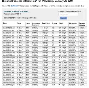
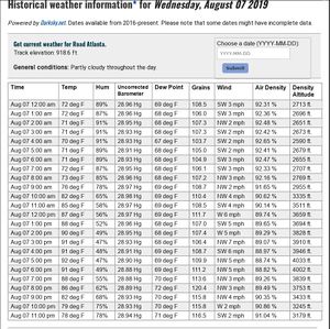
https://airdensityonline.com/track-results/Road_Atlanta/ | * [https://airdensityonline.com/track-results/Road_Atlanta/ Density Altitude at Road Atlanta] (proxy for Lake Lanier) | ||
https://airdensityonline.com/track-history/Road_Atlanta/yesterday | * [https://airdensityonline.com/track-history/Road_Atlanta/yesterday Density Altitude at Road Atlanta Yesterday] | ||
https://www.weather.gov/epz/wxcalc_densityaltitude | * [https://www.weather.gov/epz/wxcalc_densityaltitude Weather.gov Density Altitude Calculator] Requires actual pressure, temp and humidity | ||
https://en.wikipedia.org/wiki/Density_altitude | * [https://en.wikipedia.org/wiki/Density_altitude Density Altitude on Wikipedia] | ||
https://en.wikipedia.org/wiki/Pressure_altitude | * [https://en.wikipedia.org/wiki/Pressure_altitude Pressure Altitude on Wikipedia] | ||
{{Template:Wind_Data}} | {{Template:Wind_Data}} | ||
[[Category:Weather]] | [[Category:Weather]] | ||
Revision as of 12:26, 1 October 2019
Description
Pressure Altitude is the height above a standard datum plane (SDP), which is a theoretical level where the weight of the atmosphere is 29.92 "Hg (1,013.2 mb) as measured by a barometer
Effect
Sources and Links
- Density Altitude at Road Atlanta (proxy for Lake Lanier)
- Density Altitude at Road Atlanta Yesterday
- Weather.gov Density Altitude Calculator Requires actual pressure, temp and humidity
- Density Altitude on Wikipedia
- Pressure Altitude on Wikipedia

